Geoinformatics Intelligence
Hello Audience,
I am Gourav Panchal. I am currently working as a GIS Officer at Vasudha Foundation. I earned my post-graduation degree in Geoinformatics from TERI University, Delhi, India. I have more than 6 years of experience in the field of GIS/Remote Sensing.
I have my expertise in Agriculture, Water Resource, Glacier and Urban. I know how to use Remote Sensing & GIS in these fields.

Extract Water in Seconds from SAR Data| Step-by-Step Tutorial #arcgis #remotesensing #gis

How to Extract Common Area of Overlapping Shapefiles in ArcGIS| Step by Step

Watershed Delineation using DEM in ArcGIS | Step-by-Step Tutorial #WatershedDelineation #ArcGIS

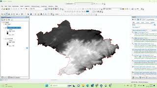
How to Create a Slope Map in ArcGIS | Step by Step Tutorial #Slopemap #gis #gisforbeginners

Landsat 8,9 Image Download from Google Earth Engine using Chat GPT. #LandsatDownload #GEE #chatgpt

Map Making of LULC in ArcGIS. How to make Study Area Map in ArcGIS. #studyareamap

How to make a Study Area Map in ArcGIS. #StudyAreaMap #MapDesign #GISforBeginners

ArcGIS Tutorial: Add Elevation Data from DEM Raster to Vector Layers. #DigitalElevationModel #DEM

Flood Extent Analysis using Google Earth Engine, Flood Detection Analysis, River Flood Monitoring.

Glacial Lakes Extraction using Classification method of Landsat Imagery. #glaciallake #NDWI #gis

Unsupervised Image Classification using ArcPY in ArcGIS Pro.

Sentinel-2 10m Land Use/Land Cover Data Import/Download in ARCGIS PRO.

Extract Road Route Network data from google map. Is there way to download directions(KML/Shapefile).

Distance Calculate from Polygon Feature to Point as a Showing Line Feature.
Import/Add DEM from ArcGIS Online in your ArcGIS Desktop.

Non Forest Area Extraction/Mask Out from NDVI in ArcGIS.

KML layer to shapefile Convert into ArcGIS

Post-classification corrections in improving the classification of Land Use/Land Cover

Mosaic DEM & Raster Datasets in ArcGIS - Problem Solved with mosaic dataset

How to Make Point Shapefile in ArcGIS.

How to Make Polygon Shapefile in ArcGIS

Summarizing Data in a Table using Attribute Table in ArcGIS| Summarizing Attribute Tables in ArcGIS

SRTM DEM 30 Meter Download | Downloading Digital Elevation Data (SRTM)

Built_Up Area Clip using Multiple Buffer Polygon in Batch Processing & Area Calculate In ArcGIS

How To: Import symbology from another layer—ArcGIS

Filter your LULC Feature Class by default using Definition Query. Tips & Tricks in GIS.

Uploading shapefile to Google Earth Engine

How to Merge different Shapefiles in GIS| In Just One Click

Soil-Adjusted Vegetation Index (SAVI) Calculate in ArcGIS

NDBI Calculation Using Landsat | Urban Built-Up Area Extraction in ArcGIS