Survey Society
"Welcome to Survey Society, the ultimate destination for surveying professionals and enthusiasts!
Our channel is dedicated to exploring the world of surveying, from the latest technologies and techniques to the most inspiring stories and projects.
Join us as we delve into the fascinating world of measurement and mapping, and discover how surveyors are making a difference in shaping our world.
Subscribe now and stay updated on:
- Auto level tutorials & training.
- Expert tutorials and training on Total Station.
- Inspiring stories of surveyors making an impact
- You should also have knowledge of industry-standard software tools like AutoCAD, Excel, and surveying data analysis and processing tools.
- And much more!
Let's measure the earth and make a difference together!"
As a surveyor, it's important to have a strong foundation in geomatics and cartography.

How to calculate the height of instrument method?

How to calculate Rise and Fall method? #rise&fall

What is Rise and fall method? Advantage, Formula

What is the Bowditch method of traverse survey?

Surveying Works in a Project – Step by Step

How to set DGPS on Benchmark?
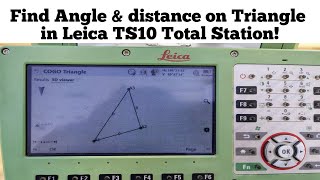
How to calculate triangle distance and angle via Leica total station | Leica 10

How find Angle between Three Points in Leica TS10 Total Station?

How to works Stake to Line on Leica TS10 total station?

How to view AutoCAD 3D layout in Leica total station?

How to records topography survey in Leica total station?

How to find offset coordinate with bearing?

How to find angle between two lines with bearing?

How to calculate Distance & bearing between two coordinates on a Scientific Calculator?

Find point coordinates with bearing, reference point, and angle?

Calculate coordinates of the remaining corners of a triangle given one corner's coordinates & angle?

Surveyor Song | Music Video for Survey Engineer #surveysociety

How to calculate Open Travers in an Excel sheet?

How to calculate bearing and distance from two coordinates? Easy Formula

What is the Scale Factor in Surveying?

How to change the Grid Format in Leica TS07? (Northing,Easting to Easting,Northing)

How to work Orientate with Line Backsight function in Leica total station | Leica TS10

How to do Know Backsight at Leica Total Station? | Leica TS10

Travers Survey in Topcon Total Station | Open Traversing

Multiple Backsight on Leica TS10 Total Station

How to use Leica TS10 total station as an Auto Level Mechine?

How to set orientation back sight on Leica TS10?

How to find Bearing and Distance in Leica TS07 Total Station?

How to create a plot using a single coordinate with a Total Station?

How to check Verticality in any Structures? | Verticality checking with Total Station