Middlebury Remote Sensing
In this course we will discuss fundamentals of air- and space-based remote sensing applied to geological and environmental problems. The core goal is to understand how different wavelengths of electromagnetic radiation interact with Earth's surface, and how images collected in these different wavelengths can be used to address questions in the Earth sciences. Lectures will present theory and basics of data collection as well as applications in hydrology, vegetation analysis, glaciology, tectonics, meteorology, oceanography, planetary exploration, and resource exploration. Labs will focus on commonly-used imagery and software to learn techniques for digital image processing, analysis and interpretation in Earth science.

Computing volume from a DEM in QGIS (Lab 8, V6)

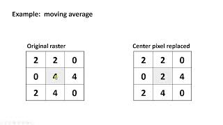
Image Interpolation (resampling) in Remote Sensing (C13, V3)

Что такое нерегулярная треугольная сеть (TIN)? (C14, V4)

What is point cloud data? (C14, v1)

Estimating elevation from stereo images (stereoscopic parallax) (C13, V2)

Overview of satellite image orthorectification (C13, V1)

Exporting a map from ArcGIS Pro (L6, V7)

Change the streaming basemap in ArcGIS Pro (L6, V6)

Export a shapefile to .kmz in ArcGIS Pro (L6, V4)

Create Ground Truth Points in ArcGIS Pro (L6, V3)

Cleaning a raster with Region Group, SetNull, and Nibble tools in ArcGIS Pro (L6, V2)

Creating a spectral separability plot in ArcGIS Pro (L5, v11)

Unsupervised classification in ArcGIS Pro (L5, V12)

Очистка растра с помощью фильтра большинства в ArcGIS Pro (L6, V1)

Supervised Classification in ArcGIS Pro (L5, V10.5)

Edit a polygon shapefile in ArcGIS pro (L5, V10)

Create a shapefile in ArcGIS Pro (L5, V9)

Principal Component Analysis in ArcGIS Pro (L5, V8)

Compute band ratios in ArcGIS Pro (L5, V5)

Stack rasters to create a multi-band raster using composite tool in ArcGIS pro (L5, V7)

Using group layers in ArcGIS Pro (L5, V6)

Rescale (normalize) raster in ArcGIS Pro (L5, V4)
Использование фокальной статистики в ArcGIS Pro (L5, V3)

Getting Started in ArcGIS Pro (L5, V2)

Intro to Crown Point Lab (L5, V1)

Clip raster by layer extent using alpha band in QGIS 3.28

Export raster values to text file in QGIS (Lab 3, V6)

Zonal Statistics Using Vector Overlay in QGIS (lab 3, V6)
Создание бинарной растровой маски в QGIS (Lb 3, V5)

Calculate NDWI using Sentinel-2 MSI Images in QGIS (Lab 3, V4)