Engr WASEEM RAJA
Welcome to our YouTube channel dedicated to all things Civil Engineering, AutoCAD Civil 3D, Quantity Surveying, and Estimation! 🏗️📐 Whether you're a student, professional, or simply curious about the world of infrastructure and construction, you've come to the right place.
#CivilEngineering #AutoCADCivil3D #QuantitySurveying #Estimation #EngineeringTutorials #Construction #Infrastructure #CAD #EngineeringEducation #costing #AutoCAD #Civil3d #Civil3DinURDU #Civil3DinHindi #estimationandcosting
Join us as we dive into comprehensive tutorials, practical tips, and insightful discussions to help you master the tools and techniques essential for success in these fields. From understanding the fundamentals of Civil Engineering principles to mastering the intricacies of AutoCAD Civil 3D, we've got you covered.
Stay tuned for regular uploads covering a wide range of topics including road design, site grading, drainage systems, quantity takeoffs, cost estimation methodologies & much more.

How to Combine Two or More Surfaces in Civil 3D | Paste Surface in #Civil3D | Lesson 13

Edit Surface in Civil 3D | Add/Remove Points and Lines | Raise or Lower Surface | Smooth Surface

Create Catchment Area and Waterdrop Analysis in Civil 3D | Civil 3D Tutorial | Lesson 11

Surface Analysis in Civil 3D | Contours Elevation Banding Directions Slopes Watersheds | Lesson 10

Create Surface in Civil 3D | Inner or Outer Boundary | Surface Style and Label | Lesson 9 | #Civil3D

How to Create a 𝐍𝐞𝐰 𝐏𝐨𝐢𝐧𝐭 𝐋𝐚𝐛𝐞𝐥 𝐒𝐭𝐲𝐥𝐞 in 𝐂𝐢𝐯𝐢𝐥 𝟑𝐃 with Advanced Settings | Lesson 8 | #Civil3D

Create New Point Style | Point Label Style | Edit or Change Point Style in Civil 3D | Lesson 7

How to Create Custom Point File Format in Civil 3D | Import Longitude Latitude in #Civil3D Lesson 6

Import Points from Excel to Civil 3D | Points Table & Group | Export Points from Civil 3D to Excel

Create Point File Format Civil 3D | Lesson 4 | Convert Excel file to CSV and Text File | SDR file

Unit and Zone Settings | How to Assign Coordinate System in Civil 3D | Lesson 3 | #Civil3D Tutorial

Civil 3D User Interface | Lesson 2 | Civil 3D Tutorial for Beginners an d Advanced | #Civil3D Basics

Start Tab in Autocad Civil 3D | Lesson 1 | #Civil #3D #Tutorials for Beginners

How to Calculate Bricks in 1 Cubic Meter in Excel - A Quantity Surveying Tutorial

How Many Bricks in 1 Cubic Meter | Brick Calculation in Wall | Civil Engineering | Urdu/Hindi

How Many Bricks in One Cubic Feet (1 Cft) in excel | How Many Bricks Required for One Cubic Feet

How Many Bricks in One Cubic Feet in URDU/Hindi | How to Find No of Bricks in a Wall

Center of Gravity and Centroid | Mechanics of Structure | Engineering Mechanics | Ch-1 | Lesson 1

How to Prepare Bar Bending Schedule of Slab in Excel | Part 2/2 | BBS of Two Way Slab | BBS in Excel

Bar Bending Schedule of Two Way Slab in Excel | Part 1/2 | BBS of Two Way Slab | Quantity Surveying

How to Create Parcel Labels in Civil 3d | Part 2/2 | Create Parcel Segment and Area Labels | L-42

How to Create Parcel in Civil 3D | Part 1/2 | Parcel Creation Tools | AutoCAD Civil 3D | L-42

Cutting Length of Haunch Bar in Excel | How to Calculate Haunch Bar Length Bar Bending Schedule Urdu

Create Roundabout Civil 3D in Hindi/Urdu with Road Approach and Turn Slip Lanes | L-41

Civil 3D Intersection Corridor Design Tools | Part 2/2 | Intersection Corridor in Civil 3D | L-40
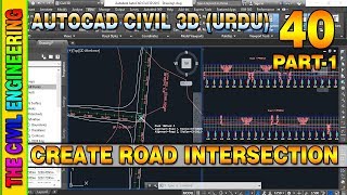
Civil 3D Intersection Design Tools | Part 1/2 | How to Create Intersection in Civil 3D | L-40

Survey in Civil 3D | Part 3/3 | Create Survey Query Builder | Point Groups in Civil 3D | L-39
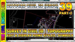
Survey in Civil 3D | Part 2/3 | Edit or Display Point Styles | Topographic Survey | L-39

Survey in Civil 3D | Part 1/3 | Survey Databases | Linework Code Set | Figure Prefix Database | L-39

Export Section View Data to Excel in Civil 3D | Corridor Points Report with Offset Elevations | L-38