FOSS4G 2025 | Introduction to libCartoSym, libCQL2 and libDE9IM
Автор: FOSS4G SotM Oceania
Загружено: 2025-12-22
Просмотров: 8
Presented by Jerome St-Louis on 21 November 2025 13:30, at FOSS4G 2025 Auckland. Track: Tools, Libraries & Visualisation
Full presentation details - https://talks.osgeo.org/foss4g-2025/t... GMWCAD
An introduction and overview of the capabilities provided by the Free and Open Source Software libCartoSym and related dependency libraries (libCQL2, libDE9IM...) implementing the candidate [OGC Cartographic Symbology 2.0 Standard](https://github.com/opengeospatial/car.... http://cartosym.org/ https://github.com/ecere/libCartoSym
libCartoSym is a Free and Open-Source Software library implementing [OGC Cartographic Symbology 2.0](https://github.com/opengeospatial/car...)
libCartoSym aims to be an implementation of the [CartoSym-CSS](https://docs.ogc.org/DRAFTS/18-067r4....) and
[CartoSym-JSON](https://docs.ogc.org/DRAFTS/18-067r4....) encodings defined in the candidate
[OGC Cartographic Symbology - Part 1: Core Model and Encodings Standard version 2.0](https://docs.ogc.org/DRAFTS/18-067r4....) Standard.
The library allows to read and write these CartoSym encodings, as well as import from and export to additional encodings of portrayal rules such as OGC [SLD](https://portal.ogc.org/files/?artifac...[SE](https://portal.ogc.org/files/?artifac...) and [Mapbox GL Styles](https://docs.mapbox.com/mapbox-gl-js/....
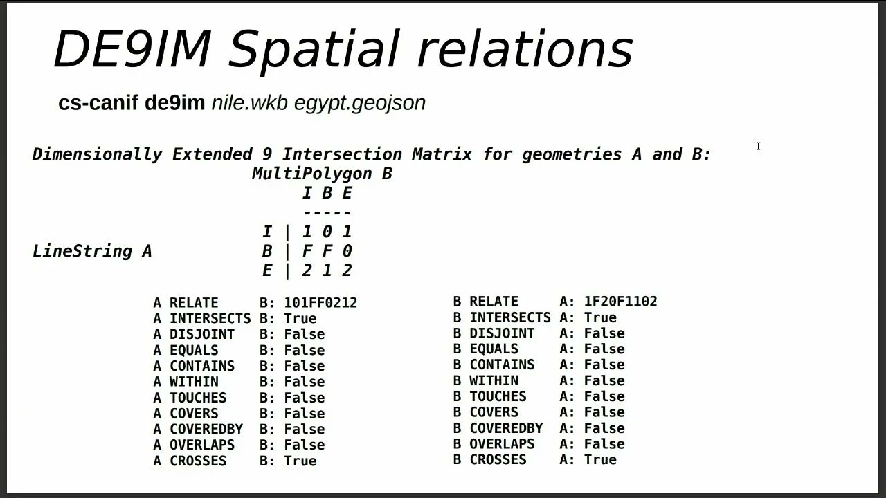
Since the CartoSym encodings extend the [OGC Common Query Language (CQL2)](https://www.opengis.net/doc/IS/cql2/1.0), the library also relies on a related open-source libCQL2 library providing support for
parsing and writing CQL2-Text and CQL2-JSON expressions, as well as run-time evaluation of CQL2 expressions. Support for performing spatial relation queries based on the
[Dimensionally Extended-9 Intersection Model](https://en.wikipedia.org/wiki/DE-9IM) is also
integrated within a jointly developed libDE9IM open-source library, and support for OGC Simple Features as well as parsing and writing geometries defined in
[Well-Known Text (WKT)](http://portal.opengeospatial.org/file...) and [GeoJSON](https://tools.ietf.org/rfc/rfc7946.txt) is also provided by related open-source libraries.
While these libraries are written in the [eC programming language](https://ec-lang.org), object-oriented bindings for libCartoSym automatically generated using Ecere's [binding generating tool (bgen)](https://github.com/ecere/bgen) will also be made available for the C, C++ and Python programming languages, with additional support planned for Java and Rust.
Acknowledgement
Financial support provided by GeoConnections, a national collaborative initiative led by Natural Resources Canada. GeoConnections supports the modernization of the Canadian Geospatial Data Infrastructure (CGDI). The CGDI is the collection of geospatial data, standards, policies, applications, and governance that facilitate its access, use, integration, and preservation.
===
https://2025.foss4g.org/
@FOSS4G
Доступные форматы для скачивания:
Скачать видео mp4
-
Информация по загрузке: