Популярное

Музыка Кино и Анимация Автомобили Животные Спорт Путешествия Игры Юмор

Интересные видео

2025 Сериалы Трейлеры Новости Как сделать Видеоуроки Diy своими руками

Топ запросов

смотреть а4 schoolboy runaway турецкий сериал смотреть мультфильмы эдисон
dTub
Скачать

Airplane Crash Site Revisited

Автор: WebsterHighlanders

Загружено: 2023-05-22

Просмотров: 1044

Описание:

00:00 hiking to crash site
01:30 start of debris field
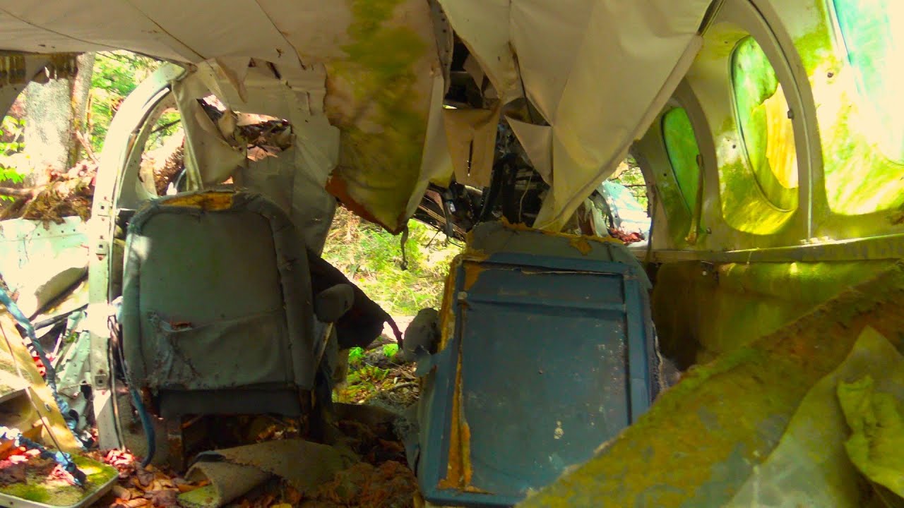
10:20 main body of aircraft wreckage
17:07 recovered flight instruments and prop

On November 28, 1995, a twin-engine Cessna 414 crashed in a remote area of the Cranberry Wilderness in Pocahontas County, West Virginia (near the Webster County line). The only occupant, 31-year-old pilot Colin Campbell, was killed on impact. The wreckage was not located until November 15, 2001, nearly six years from when the accident occurred. No human remains were ever recovered from the accident site. On the day of the accident, the weather was deteriorating quickly, and Campbell apparently flew the plane at full speed into the obscured mountain side, just a few hundred feet from its peak.

I visited the crash site twice in November 2001 and once in the Spring of 2002. Here is the video I did of my first visit in November 2001 which includes a fly-over of the site we did the day before I first hiked to the site:    • Fatal Plane Crash  

Now, nearly 28 years after the crash occurred, I paid yet another visit to the site on May 21, 2023 and not much has changed. The shortest (but most difficult) way to access the crash site is to hike up the appropriately named Hateful Run from its mouth at the Williams River (GPS coordinates for mouth of Run: 38 degrees, 21' 03" N, 80 degrees, 15' 28" W).

The straight-line hike is 1.65 miles one way, with an elevation gain of just shy of 1,300 feet, plus a drop of 200 feet and another gain of 100 feet (prepare for a longer walk "zig zagging" your way up the mountain and around fallen trees and other obstacles in the straight line).

The GPS coordinates to the lower end (i.e., start) of the debris field are: 38.334833, -80.280500 (or converted to 38 degrees, 20' 0.54" N, 80 degrees, 16' 49.8" W). These are the coordinates I used to find the lower part of the debris field and my GPS took me to within 10 feet of the same using these coordinates.

The main body of the aircraft, the demolished cockpit, and where bits and pieces of the pilot's clothing were found sit at an elevation of 4,050 feet; the NTSB's aviation accident database list the GPS coordinates for this part of the site at: 38.335000, -80.28000.
The full report by the NTSB of the accident can be found at: https://app.ntsb.gov/pdfgenerator/Rep...

Airplane Crash Site Revisited

Поделиться в:

Доступные форматы для скачивания:

Скачать видео mp4

  • Информация по загрузке:

Скачать аудио mp3

Похожие видео

🔥 Tak napięty FILM, że zapomnisz o wszystkim innym | Lektor PL | GORĄCO POLECAMY

🔥 Tak napięty FILM, że zapomnisz o wszystkim innym | Lektor PL | GORĄCO POLECAMY

КИЕВ ❗ СРОЧНО❗ЭВАКУАЦИЯ ЛЮДЕЙ❗

КИЕВ ❗ СРОЧНО❗ЭВАКУАЦИЯ ЛЮДЕЙ❗

*FATAL PLANE CRASH FOUND! Exploring the Remnants of Northeast Flight 792 | Mount Success

*FATAL PLANE CRASH FOUND! Exploring the Remnants of Northeast Flight 792 | Mount Success

Carole Lombard Airplane Crash Location with on site visit, January 16, 1942.

Carole Lombard Airplane Crash Location with on site visit, January 16, 1942.

Discovering The Wreckage Of A 50 Year Old Plane Crash Deep In The Seneca Creek Backcountry

Discovering The Wreckage Of A 50 Year Old Plane Crash Deep In The Seneca Creek Backcountry

Съёмка пуль со скоростью 20 000 000 кадров в секунду! — Баллистическая высокоскоростная съёмка

Съёмка пуль со скоростью 20 000 000 кадров в секунду! — Баллистическая высокоскоростная съёмка

B-24 Crashed, Survived 81 Days in -50° with No Food : Alaska's Impossible Survival

B-24 Crashed, Survived 81 Days in -50° with No Food : Alaska's Impossible Survival

ДТП. Подборка на видеорегистратор за 16.01.2026 Январь 2026

ДТП. Подборка на видеорегистратор за 16.01.2026 Январь 2026

Eerie Ruins of Johnstown Coal & Coke | Panther Gulch, West Virginia

Eerie Ruins of Johnstown Coal & Coke | Panther Gulch, West Virginia

Hiker Finds Horrific 1970's Plane Crash Site in the Woods (No Survivors)

Hiker Finds Horrific 1970's Plane Crash Site in the Woods (No Survivors)

Cessna 206H - Failed Start up Attempts

Cessna 206H - Failed Start up Attempts

Humpback Mountain Airplane Crash Site – Navy T-28 Aircraft Wreckage – Appalachian Trail Virginia

Humpback Mountain Airplane Crash Site – Navy T-28 Aircraft Wreckage – Appalachian Trail Virginia

Kevin Lacey Repos a Crusty Cessna 421!

Kevin Lacey Repos a Crusty Cessna 421!

ЧТО СКРЫВАЮТ РАДИОВОЛНЫ?

ЧТО СКРЫВАЮТ РАДИОВОЛНЫ?

🔥 ТАК ВОТ КАК ПОТОПИЛИ КРЕЙСЕР МОСКВА! Малоизвестные ФАКТЫ ДАННОЙ ОПЕРАЦИИ

🔥 ТАК ВОТ КАК ПОТОПИЛИ КРЕЙСЕР МОСКВА! Малоизвестные ФАКТЫ ДАННОЙ ОПЕРАЦИИ

The Haunted Remains of Allegheny Airlines Flight 853 Crash Site, 1969

The Haunted Remains of Allegheny Airlines Flight 853 Crash Site, 1969

Hiking to Peaks of Otter B-25 Plane Crash | Appalachian Mountains, Ep. 5

Hiking to Peaks of Otter B-25 Plane Crash | Appalachian Mountains, Ep. 5

Другие пилоты мне не верили, пока не увидели кадры!

Другие пилоты мне не верили, пока не увидели кадры!

HAO L-23 Super Blaník - Spins and stalls

HAO L-23 Super Blaník - Spins and stalls

ДЕТИ АВТОПИЛОТА! Turkish Airlines 1951, 25 февраля 2009 год.

ДЕТИ АВТОПИЛОТА! Turkish Airlines 1951, 25 февраля 2009 год.

© 2025 dtub. Все права защищены.


  • Контакты
  • О нас
  • Политика конфиденциальности


Контакты для правообладателей: infodtube@gmail.com