Популярное

Музыка Кино и Анимация Автомобили Животные Спорт Путешествия Игры Юмор

Интересные видео

2025 Сериалы Трейлеры Новости Как сделать Видеоуроки Diy своими руками

Топ запросов

смотреть а4 schoolboy runaway турецкий сериал смотреть мультфильмы эдисон
dTub
Скачать

Contour lines, what they are and how to use them to help you read a map.

Автор: Southern Upland Way

Загружено: 2025-01-16

Просмотров: 200

Описание:

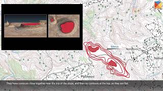
Contour lines are one of the most useful things shown on a map but there are a few things that you need to know in order to use them effectively to help you navigate while walking the hills of Scotland.

If you would like to watch my introduction to how to use a map you can see it here    • How to Read a Map. Basic Map Reading Skill...  

If you would like more information on what maps are the best to get for walking the Southern Upland Way you can find that here    • What map should you take with you when wal...  

The Southern Upland Way is a 214 mile coast to coast path from Portpatrick on the West Coast of Scotland to Cockburnspath on the east. For more information visit our website at https://dgtrails.org/southern-upland-way.

This video was produced by Dumfries and Galloway Council's Southern Upland Way Ranger Service with funding from ScottishPower Renewables Kilgallioch Windfarm.

Contour lines, what they are and how to use them to help you read a map.

Поделиться в:

Доступные форматы для скачивания:

Скачать видео mp4

  • Информация по загрузке:

Скачать аудио mp3

Похожие видео

What map should you take with you when walking the Southern Upland Way

What map should you take with you when walking the Southern Upland Way

How do you use a Scottish Mountain Bothy?

How do you use a Scottish Mountain Bothy?

Навигация с использованием контурных линий

Навигация с использованием контурных линий

Понимание контурных линий

Понимание контурных линий

The History of the Southern Upland Way, Scotland's Coast to Coast Path

The History of the Southern Upland Way, Scotland's Coast to Coast Path

Understanding Contour Lines

Understanding Contour Lines

Contour Lines

Contour Lines

The dead body that lead to the discovery of an iron age cranog. The Black Loch at Sanquhar

The dead body that lead to the discovery of an iron age cranog. The Black Loch at Sanquhar

How to Read a Map. Basic Map Reading Skills for walking in Scotland

How to Read a Map. Basic Map Reading Skills for walking in Scotland

Understanding Cross Contours - Thinking Like a 3D Modeler

Understanding Cross Contours - Thinking Like a 3D Modeler

Что происходит, когда пилот совершает неудачную посадку на американский авианосец?

Что происходит, когда пилот совершает неудачную посадку на американский авианосец?

Using contours to identify landforms

Using contours to identify landforms

Contour Map / Topographic Map Reading

Contour Map / Topographic Map Reading

Hiking 50 Miles In Scotlands Largest Forest

Hiking 50 Miles In Scotlands Largest Forest

Durisdeer Pass Roman Road and the Best Preserved Roman Fort in Scotland

Durisdeer Pass Roman Road and the Best Preserved Roman Fort in Scotland

Правду скрывают, чтобы не вызвать панику. Открытие Петра Гаряева

Правду скрывают, чтобы не вызвать панику. Открытие Петра Гаряева

Украина отследила

Украина отследила "рождественский груз", а затем потопила его целиком.

ПОСЛЕ СМЕРТИ ВАС ВСТРЕТЯТ НЕ РОДСТВЕННИКИ, А.. ЖУТКОЕ ПРИЗНАНИЕ БЕХТЕРЕВОЙ. ПРАВДА КОТОРУЮ СКРЫВАЛИ

ПОСЛЕ СМЕРТИ ВАС ВСТРЕТЯТ НЕ РОДСТВЕННИКИ, А.. ЖУТКОЕ ПРИЗНАНИЕ БЕХТЕРЕВОЙ. ПРАВДА КОТОРУЮ СКРЫВАЛИ

Почему Азовское море — самое опасное в мире

Почему Азовское море — самое опасное в мире

ПЕШКОМ из Архыза в Красную Поляну | Поход

ПЕШКОМ из Архыза в Красную Поляну | Поход

© 2025 dtub. Все права защищены.


  • Контакты
  • О нас
  • Политика конфиденциальности


Контакты для правообладателей: [email protected]