Ferrata Sass Brusai. Veneto, Monte Grappa
Автор: STEPS to the SKY
Загружено: 2023-07-11
Просмотров: 1694
Il percorso prevede: ferrata Sass Brusai in salita (I parte - ripresa in questo video) e Carlo Guzzella in discesa (II parte - v. altro video)
** english version below **
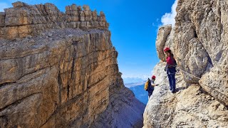
Percorso (I parte): partenza dal ristorante S.Liberale (600 m), Paderno del Grappa (TV). Ripido avvicinamento nel bosco di 1.30h circa, fino a quota 1.170 m. Li è presente l’attacco della ferrata Sass Brusai, che sale con un misto di tratti attrezzati e non. Verso la fine presente un piccolo ponte tibetano. Uscita a 1.532 m, in vetta al monte Boccaor
Percorso (II parte): dalla cima del Boccaor attraversamento delle trincee della I guerra mondiale, fino alla SP 141. Proseguendo (att. se presenti lavori) si incrocia la ferrata Carlo Guzzella, che percorriamo in discesa, evitando il tratto finale (più difficile) della Guzzella. Resto della discesa fra decine di camosci
Distanza: 9 km (anello). Dislivello: 1.104 m, da 600 m a 1.532 m
Sentiero EEA, 2 ferrate, in cui si può progredire su solida roccia. Entrambe fisicamente e tecnicamente impegnative. Valutare bene se percorrere la Guzzella in discesa, ed in particolare il tratto finale (iniziale in discesa) che inizia dal Monte Grappa
Equipaggiamento: casco, guanti da arrampicata, scarpette con climbing zone, kit ferrata, bastoni
Periodo: Luglio
Le valutazioni/considerazioni sul sentiero indicato, sia nel video che nelle descrizioni, sono soggettive, e non devono essere prese a riferimento.
Track: https://it.wikiloc.com/percorsi-via-f...
The evaluations/considerations on the path indicated, both in the video and in the descriptions, are subjective, and must not be taken as a reference.
Itinerary (part I): departure from the S. Liberale restaurant (600 m), Paderno del Grappa (TV). Steep approach in the woods of about 1.30h, up to an altitude of 1,170 m. There is the start of the Sass Brusai ferrata, which climbs with a mixture of equipped and non-aided sections. Towards the end there is a small Tibetan bridge. Exit at 1,532 m, on the summit of Mount Boccaor
Itinerary (part II): from the top of Boccaor, crossing the trenches of the First World War, up to the SP 141. Continuing (current if works are present) you cross the Carlo Guzzella ferrata, which you follow downhill, avoiding the final stretch (more difficult) of Guzzella. Rest of the descent among dozens of chamois
Distance: 9 km (ring). Altitude difference: 1,104m, from 600m to 1,532m
EEA path, 2 via ferratas, where you can progress on solid rock. Both physically and technically demanding. Evaluate carefully whether to go down the Guzzella, and in particular the final stretch (initial downhill) which starts from Monte Grappa
Equipment: helmet, climbing gloves, shoes with climbing zone, via ferrata kit, poles
Period: July
Le valutazioni/considerazioni sul sentiero indicato, sia nel video che nelle descrizioni, sono soggettive, e non devono essere prese a riferimento.
The evaluations/considerations on the path indicated, both in the video and in the descriptions, are subjective, and must not be taken as a reference.

Доступные форматы для скачивания:
Скачать видео mp4
-
Информация по загрузке: