Популярное

Музыка Кино и Анимация Автомобили Животные Спорт Путешествия Игры Юмор

Интересные видео

2025 Сериалы Трейлеры Новости Как сделать Видеоуроки Diy своими руками

Топ запросов

смотреть а4 schoolboy runaway турецкий сериал смотреть мультфильмы эдисон
dTub
Скачать

Exploring the YellowScan Surveyor Ultra 3rd Gen: A Comprehensive Review.

Автор: A-GEO

Загружено: 2024-02-20

Просмотров: 1423

Описание:

Join us on our YouTube channel as we delve into the innovative capabilities of the YellowScan Surveyor Ultra 3rd generation LiDAR system!
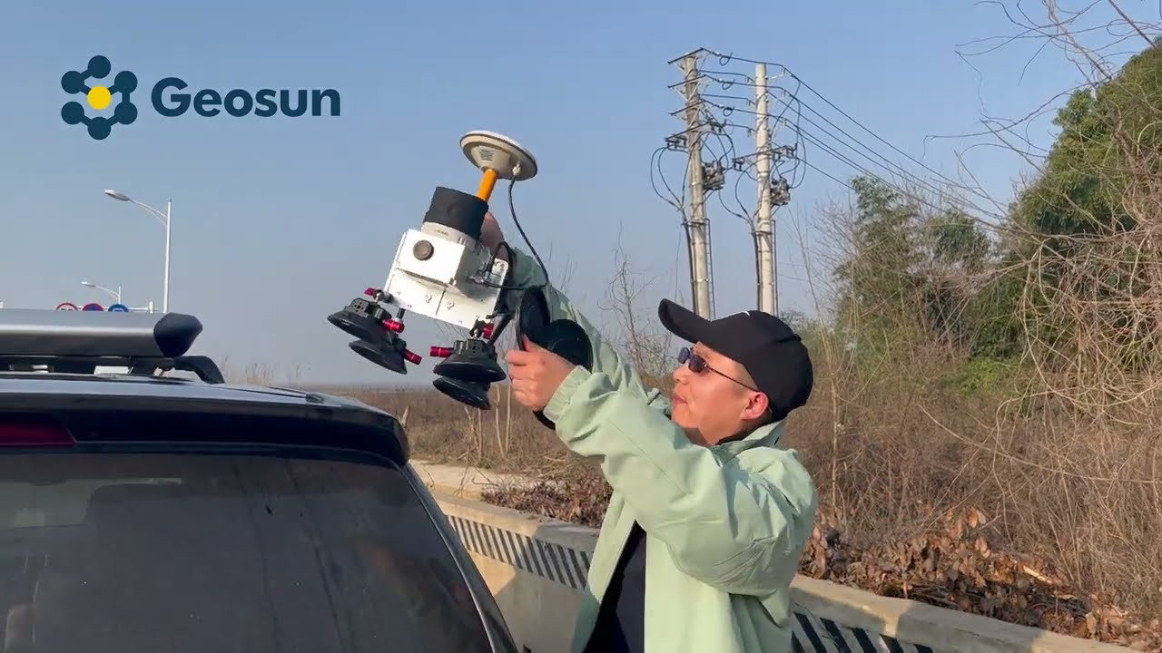
This cutting-edge technology offers seamless integration into various UAV platforms, including multirotors, fixed-wing VTOL, and helicopters, making it a versatile solution for a wide range of surveying missions.

Discover how the Surveyor Ultra's 360° field of view revolutionizes vertical mapping and mobile mapping, delivering unparalleled vegetation penetration with its 32 laser beams. From vertical inspections of buildings and bridges to coastal erosion monitoring and beyond, this system is engineered to meet diverse mapping needs with precision and efficiency.

Learn how the Surveyor Ultra simplifies operation with its "Just Press the Yellow Button" philosophy, ensuring a turn-key experience for users. With its embedded camera for colorization and compatibility with optional single or dual-camera modules, this device empowers users to collect LiDAR and RGB data seamlessly.

Explore the ease of data processing and generation with YellowScan's all-in-one software solution, enabling quick extraction, processing, and visualization of point clouds right after flight acquisition. Invest in productivity-enhancing features that streamline your workflow and boost confidence in the deliverables produced for your projects.

Don't miss out on this in-depth exploration of the YellowScan Surveyor Ultra, designed to make surveying tasks more efficient and effective than ever before! Subscribe to our channel and stay tuned for more insightful content on the latest technology in UAV surveying.

Best regards,
A-GEO
www.a-geo.info

Exploring the YellowScan Surveyor Ultra 3rd Gen: A Comprehensive Review.

Поделиться в:

Доступные форматы для скачивания:

Скачать видео mp4

  • Информация по загрузке:

Скачать аудио mp3

Похожие видео

GS-260X LiDAR for Mobile Mapping | Complete Guide & Tutorial

GS-260X LiDAR for Mobile Mapping | Complete Guide & Tutorial

Как создать и обвести 3D-текст в FreeCAD (пошаговая инструкция)

Как создать и обвести 3D-текст в FreeCAD (пошаговая инструкция)

Dji Matrice 300 & YellowScan Mapper+ (LiDAR)

Dji Matrice 300 & YellowScan Mapper+ (LiDAR)

YellowScan/Cloudstation/Colorization/Ortho

YellowScan/Cloudstation/Colorization/Ortho

Kā es braucu Zemīt mērīt 2.

Kā es braucu Zemīt mērīt 2.

ИИ-роботы и Технологии Будущего на Выставке в США 2026

ИИ-роботы и Технологии Будущего на Выставке в США 2026

Тепловизионная съемка при осмотре дома

Тепловизионная съемка при осмотре дома

КАК ТАКОЕ ВОЗМОЖНО? ГОРОД ПОСТРОЕН БЕЗ ТЕХНИКИ НА ВЫСОТЕ 2400 МЕТРОВ

КАК ТАКОЕ ВОЗМОЖНО? ГОРОД ПОСТРОЕН БЕЗ ТЕХНИКИ НА ВЫСОТЕ 2400 МЕТРОВ

Matrix III apskats | GNSS RTK ar AR,  LR lāzeri un citām funkcijām.

Matrix III apskats | GNSS RTK ar AR, LR lāzeri un citām funkcijām.

Как Сделать Настольный ЭЛЕКТРОЭРОЗИОННЫЙ Станок?

Как Сделать Настольный ЭЛЕКТРОЭРОЗИОННЫЙ Станок?

⚡️ МИЛОВ: Нефть по $39 добила бюджет рф! Масштабный блэкаут и аварии ЖКХ СРАЗУ В НЕСКОЛЬКИХ городах

⚡️ МИЛОВ: Нефть по $39 добила бюджет рф! Масштабный блэкаут и аварии ЖКХ СРАЗУ В НЕСКОЛЬКИХ городах

Самая спорная батарея на выставке CES 2026

Самая спорная батарея на выставке CES 2026

Как найти свободный участок в любом населенном пункте РФ

Как найти свободный участок в любом населенном пункте РФ

System Design Concepts Course and Interview Prep

System Design Concepts Course and Interview Prep

In the field with the YellowScan Surveyor Ultra for a flight

In the field with the YellowScan Surveyor Ultra for a flight

AlphaGEO DG1 – vieda GNSS sistēma ekskavatoriem | Iespējas un pielietojums.

AlphaGEO DG1 – vieda GNSS sistēma ekskavatoriem | Iespējas un pielietojums.

Adding Metashape GCPs - Be Careful!

Adding Metashape GCPs - Be Careful!

Путина предадут элиты и он исчезнет как Мадуро: будущее РФ отработано в Венесуэле. Мишустин на смену

Путина предадут элиты и он исчезнет как Мадуро: будущее РФ отработано в Венесуэле. Мишустин на смену

ВОЗВРАЩЕНИЕ - САМЫЙ БЫСТРЫЙ в мире дрон V4

ВОЗВРАЩЕНИЕ - САМЫЙ БЫСТРЫЙ в мире дрон V4

Jaunums no STONEX - S880 GNSS ar AR kameru. Iepazīšanās un lauku tests.

Jaunums no STONEX - S880 GNSS ar AR kameru. Iepazīšanās un lauku tests.

© 2025 dtub. Все права защищены.


  • Контакты
  • О нас
  • Политика конфиденциальности


Контакты для правообладателей: infodtube@gmail.com