MacGillycuddy’s Reeks - The Full 10 Summit Traverse
Автор: Laura Homans
Загружено: 2021-10-18
Просмотров: 1021
Disclaimer: This info is a personal opinion and we are not liable if you get injured or killed. The mountains can be dangerous.
MacGillycuddy’s Reeks – Full 10 Summit Traverse
20 km 9-15 hours
Summits and Irish OS grid refs
(1) Cruach Mhor, 932 m, 841 847
(2) Big Gun, 939 m, 841 845.
(3) Cnoc na Peiste, 988 m, 836 842.
(4) Maolan Bui, 973 m, 832 838.
(5) Cnoc an Chuillin, 958 m, 823 833.
(6) Caher, 1001 m, 793 838.
(7) Caher NW, 975 m, 790 840
(8) Carrauntoohil, 1039 m, 803 844.
(9) Knockoughter, 959 m, 801 847.
(10) Beenkeragh, 1010 m, 801 853.
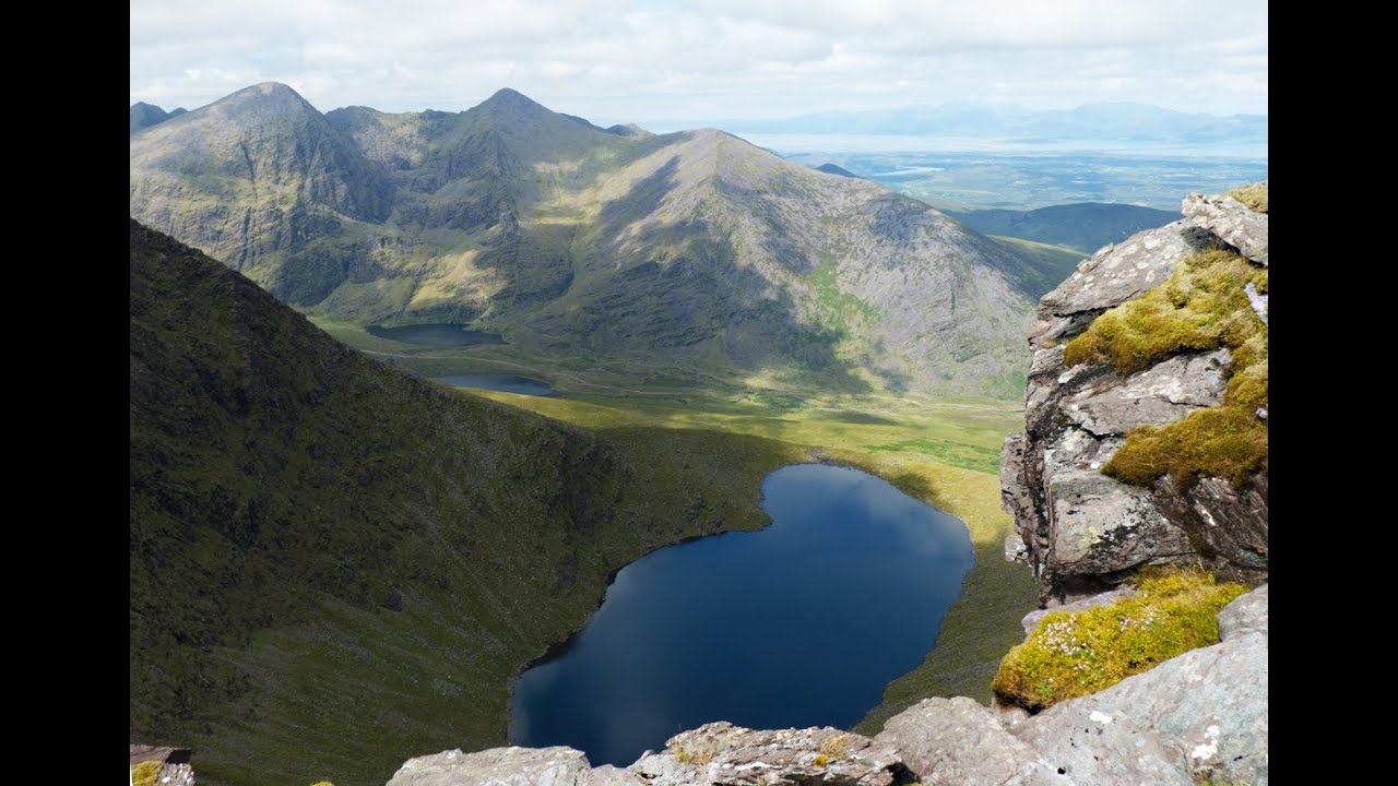
MacGillycuddy’s Reeks is the highest mountain range in Ireland with the summit of Carrauntoohil as the highest point on the ridge and the whole of Ireland. The complete traverse is a long mountain day, starting at around 150 metres, covering 20 km of hiking / scrambling and crossing 10 summits, all over 3000 feet. Navigation is quite easy on a clear day but a map and compass with the skills to use them are essential, regardless of the conditions.
The route
(1) From Cronin’s Yard walk up the main path as if you were heading straight up towards Carrauntoohil. A bit further on, rather than crossing the bridge over the river, take a path up to the left at a sign saying 'Cronin's yard loop walk' which eventually bends leftwards towards the steep stream taking you up towards the small mountain lake called Cummeenapeasta. At the point where the stream meets the lake, turn towards your left and ascend the ridge line towards the first summit of Cruach Mhor, 932 m. The top has a small Catholic shrine in the side of a large cairn which will identify your location.
(2) Drop down S and climb back up the ridge over some exposed grade 2 scrambling, eventually reaching the summit of Big Gun, 939 m, this is a sharp pinanacle
(3) Drop off SW on slightly easier terrain to a col then back up the ridge to the summit cairn of Cnoc na Peiste, 988 m.
(4) The terrain becomes much better defined hiking ground from now so drop down SSW to another col then back up SW to the summit cairn of Maolan Bui, 973 m.
(5) Drop down SW onto a grass col wandering back up slightly before descending a little way. Going back up from here you will strart curving around NW, getting you to the summit cairn of Cnoc an Chuillin, 958 m.
(6) Drop NW to the col at the top of a gully on your right side, continuing on, the ground will yoyo a bit until you reach the top of Devil's Ladder, the route most take to the top of Carrauntoohil. Continue up the main route to Carrauntoohil, following the cairns. Getting to exactly 900 m, turn left or W, to cut out Carrauntoohil for now and intercept the ridge to Caher, the tops of both Caher summits should become visible before reaching the ridge. Follow the ridge, staying on the safer left side getting you up to the summit of Caher, 1001 m.
(7) Continue on the ridge and ascend a clear path to a col then back up to a cairn which marks the summit of Caher NW, 975 m.
(8) About turn and return over Caher, dropping back to the col to start heading back up NE to top out at Carrauntoohil, 1041 m. A large iron cross on the summit marks the top of Ireland
(9) Now about turn and retrace your path a few metres down to a grassy flat bit as though you were going back to Caher and turn right towards the rest of the ridge. After dropping down onto easy ground you will be faced with a longer, grade 1 scrambling section heading NW to take you to the next summit of Knockoughter, 959 m, there is no marker on the top.
(10) Drop off the scrambling traverse and at a rocky col, start turning NE to ascend a rocky ridge where a path will zig zag to the top of Beenkeragh, 1010 m.
(11) The drop off from Beenkeragh is a matter of choice, you can drop directly NE onto a boulder field or take a NW bearing to go round the worst of it and swing E to set you up on the start of a long tongue towards Knockbrinnea. By sticking to the high ground along the saddle, the summit cairn of Knockbrinnea will be reached. Follow the rest of the saddle NE, curving E over rocky ground and eventually you will hit the end of the ridge at a steep drop off. Look sharply to you right, maybe retracing your steps a 100 metres or so and drop off the side on a S bearing towards the main tourist path at the bottom of the valley. The drop off down the hill is not on a path and the terrain is pretty horrible. At the path head back down the valley, crossing the bridge on the right to take you back to Cronin's Yard. Well done!

Доступные форматы для скачивания:
Скачать видео mp4
-
Информация по загрузке: