Популярное

Музыка Кино и Анимация Автомобили Животные Спорт Путешествия Игры Юмор

Интересные видео

2025 Сериалы Трейлеры Новости Как сделать Видеоуроки Diy своими руками

Топ запросов

смотреть а4 schoolboy runaway турецкий сериал смотреть мультфильмы эдисон
dTub
Скачать

15-minute cities - Using GIS to understand local accessibility

Автор: British Cartographic Society

Загружено: 2022-10-31

Просмотров: 6373

Описание:

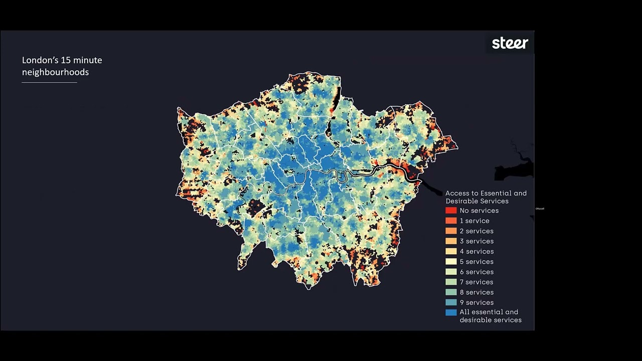
Locally focused and sustainable models for planning cities have been increasing in popularity, such as the 15-minute city. With planners keen to embrace this model, Steer has developed a spatial analysis method to determine local accessibility as a measure of a defining 15-minute city, while also considering some of the local challenges and opportunities an area may experience. Oli will provide an overview of the method and apply it to London and other locations throughout the UK.

Oliver Russell, Steer

BCS Conference 2022 - Talk 8

15-minute cities - Using GIS to understand local accessibility

Поделиться в:

Доступные форматы для скачивания:

Скачать видео mp4

  • Информация по загрузке:

Скачать аудио mp3

Похожие видео

Transit Accessibility to Destinations

Transit Accessibility to Destinations

54 Space Syntax for Starters

54 Space Syntax for Starters

ГИС-техник против ГИС-аналитика против ГИС-разработчика

ГИС-техник против ГИС-аналитика против ГИС-разработчика

Mapping the Estate

Mapping the Estate

Accessibility Analysis Video 1

Accessibility Analysis Video 1

Public Transit Analysis in ArcGIS

Public Transit Analysis in ArcGIS

Расчет статистически значимых горячих точек с помощью плагина анализа горячих точек в QGIS

Расчет статистически значимых горячих точек с помощью плагина анализа горячих точек в QGIS

Teatime Talk - Mapping My World - U.S. Geological Survey Topographic Mapping

Teatime Talk - Mapping My World - U.S. Geological Survey Topographic Mapping

How to make isochrones on QGIS using TravelTime (1/3)

How to make isochrones on QGIS using TravelTime (1/3)

САМЫЙ БЫСТРЫЙ способ изучить современные ГИС и ДЕЙСТВИТЕЛЬНО получить работу

САМЫЙ БЫСТРЫЙ способ изучить современные ГИС и ДЕЙСТВИТЕЛЬНО получить работу

Network Analyst: Creating Network Datasets

Network Analyst: Creating Network Datasets

Извлечение данных из OpenStreetMap с помощью QGIS и QuickOSM

Извлечение данных из OpenStreetMap с помощью QGIS и QuickOSM

Creating a Network Dataset with Public Transit Data

Creating a Network Dataset with Public Transit Data

Introduction to QGIS

Introduction to QGIS

Dogs, disease and displacement: experiments in mapping movement

Dogs, disease and displacement: experiments in mapping movement

Interview with Gary Priestnall - About the Nottingham City Projection Augmented Relief Model (PARM)

Interview with Gary Priestnall - About the Nottingham City Projection Augmented Relief Model (PARM)

M7G CLOSEST FACILITY ANALYSIS IN ARCGIS PRO

M7G CLOSEST FACILITY ANALYSIS IN ARCGIS PRO

Teatime Talk - Producing an orienteering map

Teatime Talk - Producing an orienteering map

ГИС и Python: лучшие курсы для изучения геопространственного Python

ГИС и Python: лучшие курсы для изучения геопространственного Python

20 ГИС-инструментов, которые должен знать каждый геопространственный аналитик

20 ГИС-инструментов, которые должен знать каждый геопространственный аналитик

© 2025 dtub. Все права защищены.


  • Контакты
  • О нас
  • Политика конфиденциальности


Контакты для правообладателей: infodtube@gmail.com