Driving Hoddle Grid North/South Bound | October 2021| Lockdown 6.5 | Melbourne Australia | 4K UHD
Автор: Roaming N Watching
Загружено: 2021-10-01
Просмотров: 3878
Driving Hoddle Grid without NORMAL traffic during Lockdown 6.5, October 2021, Melbourne Australia
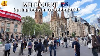
Hoddle Grid is the contemporary name given to the approximately 1-by-0.5-mile (1.61 km × 0.80 km) grid of streets that form the central business district of Melbourne, Australia. Bounded by Flinders Street, Spring Street, La Trobe Street, and Spencer Street, it lies at an angle to the rest of the Melbourne suburban grid, and so is easily recognisable. It is named after the surveyor Robert Hoddle, who marked it out in 1837 (to Lonsdale Street, extended to La Trobe Street the next year), establishing the first formal town plan. This grid of streets, laid out when there were only a few hundred settlers, became the nucleus for what is now Melbourne, a city of over 5 million people.
https://en.wikipedia.org/wiki/Hoddle_...
Timestamps
00:00 Start ( Intersection Spencer St - Flinders St )
00:11 Spencer St
02:39 La Trobe St
03:30 King St
05:56 Flinders St
06:33 William St
09:30 La Trobe St
11:02 Queen St
13:14 Flinders St
14:13 Elizabeth St
18:20 La Trobe St
20:26 Russell St
23:17 Flinders St
24:20 Exhibition St
28:48 Victoria St - Nicholson St
31:16 Spring St
34:15 Flinders Lane
35:06 Exhibition St
35:20 Flinders St
39:00 Finish ( Intersection Flinders St - Spencer St )
Please LIKE, SUBSCRIBE, SHARE and COMMENT if you like my videos.
For more videos:
/ roamingnwatching

Доступные форматы для скачивания:
Скачать видео mp4
-
Информация по загрузке: