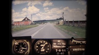
BC Road Trip Time Machine, Highway 17 - Victoria to Swartz Bay, 1966
Автор: BC Ministry of Transportation and Transit
Загружено: 20 июл. 2019 г.
Просмотров: 56 752 просмотра
Hey Victoria! Are you ready for your time travel close up? That’s right folks, we’ve pointed our BC Road Trip Time Machine at Highway 17 on Vancouver Island and captured the provincial capital as it was in the spring of 1966. We know you are eager to see it so, hop in and get ready to roll down memory lane.
About Highway 17 (Patricia Bay Highway): This busy corridor actually consists of two separate highways, one on southern Vancouver Island, the other on the lower mainland, connected by a ferry.
Known locally as the Pat Bay Highway, the island section of BC Highway 17 runs between Victoria and the Swartz Bay Ferry Terminal, north of Sidney on the Saanich Peninsula.
A lot has changed on this route over the years, almost too much to list, so keep your eyes peeled for these video highlights:
(0:05) Prior to the current alignment separating north and southbound traffic via the Blanshard extension (1978), Highway 17 started on Douglas Street near Carey Road. Before the highway was officially numbered in the 1960s, it was called East Saanich Road along a large portion of the route.
(0:10 – 0:16) In 1966, McKenzie Avenue was a small rural street with no connection to Highway 1. Highway traffic travelled alongside the Swan Lake/Christmas Hill area, then across McKenzie Avenue, towards Royal Oak. If you look closely, you can see school children along either side of the highway, possibly heading to Pacific Christian School nearby.
(0:32) Quadra Street joins up with the highway on the right. The Quadra Street overpass, connecting with the Royal Oak shopping area won’t be built until the 1970s.
(0:36) Junction of Highway 17 and 17A (also known as West Saanich Road). This route accessed the famous Butchart Gardens, as well as the ferry across the Saanich Inlet to Mill Bay. 17A was a formal alternate route through the peninsula. Highway 17A was designated in 1962, but lost its designation in 2000.
(0:45-0:53) Before the divided highway of today, Highway 17 ran directly in front of Beaver Lake Park, along what is now called Elk Lake Drive.
(1:00) Haliburton Road on your right
(1:16) Sayward Road Intersection
(1:40) Keating Cross Road exit
(1:42) East Saanich Road continues off to the left
(1:48) Island View Road intersection
(2:07) Mt. Newton Cross Road intersection
(2:40) McTavish Road intersection
(2:58) Beacon Avenue Intersection and Sidney
(3:07-3:37) Road widening work to and from Swartz Bay Ferry Terminal
(3:27) Wain Road intersection
What are Photologs?
“Photologs” were created to capture road condition information across the province and give our engineers the ability to study a particular stretch of road without having to travel into the field.
The original photologs were collected by rigging a camera onto the dash of a car that took still images every 80 feet or so and then running them all together as a single film. Pretty cool, eh? As far as we know, the “Highways Department” (as it was then known) was the first organization in Canada to collect information this way.
Looking back on these old reels reveals a lot more than just pavement condition. The camera installed onto the dash of a car and driven over 9,000 km of BC highways captured some incredible glimpses of our province during the heyday that was the 60’s. So, sit back, relax and watch this glimpse of a world long gone by in the rear-view mirror.
Are you patiently waiting to see footage of a particular BC highway that we haven’t shared yet? Let us know in the comments below. Check out our favourite still images from this film and from other photologs; or, see films of other BC Highways captured so far on our journey. Get more information here: https://www.tranbc.ca/tag/bc-road-tri...

Доступные форматы для скачивания:
Скачать видео mp4
-
Информация по загрузке: