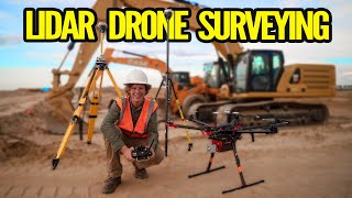
Easy LiDAR Mapping in Mountains for Forestry Protection | JOUAV CW-30E LiDAR UAV
Автор: JOUAV
Загружено: 21 апр. 2025 г.
Просмотров: 511 просмотров
Discover how the JOUAV CW-30E VTOL UAV, equipped with the RIEGL VUX-240 LiDAR, delivers high-precision mapping in the rugged mountains of Southwest China.
Chosen by the Guizhou Forestry Reserve, this advanced drone system is deployed for their forestry protection and wildlife monitoring. With up to 8 hours of flight time, the CW-30E can cover up to 120 km² (70 km² with camera), operated at flight altitudes between 1873–2150 meters, maintaining optimal accuracy even in complex terrains .
The LiDAR system captures dense, accurate point cloud data to support critical forestry surveys—tracking land changes, biomass, DEM, CHM, and even species analysis.
Learn more 🔗 https://bit.ly/3PEjqds

Доступные форматы для скачивания:
Скачать видео mp4
-
Информация по загрузке: