Mapping with a Mini 4 Pro and Dronelink
Автор: Avios Media
Загружено: 2025-07-04
Просмотров: 7015
In this video, we walk you through how to use the DJI Mini 4 Pro for professional drone mapping—now that the SDK has been released and third-party apps are supported!
If you own a DJI RC 2 controller, you’ll discover why you’ll need to purchase the DJI RC-N2 to run mapping apps like Dronelink. We guide you step-by-step through pairing the new controller with your drone and setting up your first automated mapping mission.
🔍 What You’ll Learn in This Video:
Why the DJI RC 2 doesn’t support 3rd-party apps
How to pair the RC-N2 with the Mini 4 Pro
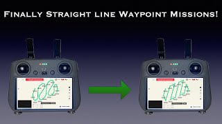
Choosing and setting up Dronelink for flight planning
Creating and flying a mapping mission
Tips for getting clean, high-quality mapping data
Whether you're surveying land, creating orthomosaics, or exploring photogrammetry workflows, this video shows how you can get pro-level results with a lightweight, affordable drone.
00:00 - Introduction
00:11 - The Catch!
00:22 - The Solution
00:48 - Connect to the RCN2
01:11 - Sign up
01:25 - Flying the mission
02:06 - Process in your favorite system

Доступные форматы для скачивания:
Скачать видео mp4
-
Информация по загрузке: