Популярное

Музыка Кино и Анимация Автомобили Животные Спорт Путешествия Игры Юмор

Интересные видео

2025 Сериалы Трейлеры Новости Как сделать Видеоуроки Diy своими руками

Топ запросов

смотреть а4 schoolboy runaway турецкий сериал смотреть мультфильмы эдисон
dTub
Скачать

Climate Classification with K-Means Clustering Model in Google Earth Engine | ERA5 & MODIS Datasets

Автор: Terra Spatial

Загружено: 2024-09-22

Просмотров: 1396

Описание:

In this video, we take you step-by-step through a fascinating process of historical climate classification using Google Earth Engine (GEE). We'll dive into the ERA5-Land and MODIS Terra datasets, applying a K-Means clustering model to uncover climate patterns over time (2000-2020).
✨ Key Highlights:
• Define a region of interest with coordinates.
• Load and combine climate variables (temperature & precipitation).
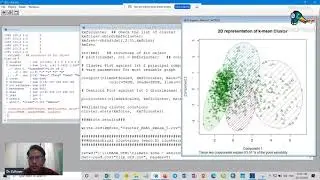
• Train a K-Means clustering model to classify the climate data.
• Visualize and export the classified climate map.
• Perform area and temperature calculations for each climate class.
• Analyse NDVI time series for the climate class with MODIS data.
📊 Charts & Visualization:
• Climate classification map with color-coded clusters.
• NDVI time series for detailed vegetation insights.
• Temperature statistics and area distribution per climate class
-----------------------------------------------------------------
🚀 Useful link:
Code link: https://code.earthengine.google.com/4...
ERA5 Dataset: https://developers.google.com/earth-e...
MODIS Terra: https://developers.google.com/earth-e...
🚀 Whether you're a climate enthusiast or a GEE pro, this video is packed with techniques to enhance your Earth observation projects!
🔔 Don't forget to like, share, and subscribe for more tutorials on climate analysis, remote sensing, and GEE!
-----------------------------------------------------------------
💰🤝🏻Join Membership to get access to perks & Support us🤝🏻💰
   / @terraspatial  
-----------------------------------------------------------------
👩‍💻 Join the Terra Spatial Community:
Engage with fellow learners, share your experiences, and get support on our dedicated community forum.
🌐 Stay connected:
📌 Subscribe to our Channel:    / @terraspatial.  .
📌 Facebook:   / terraspatial  
📌 Geosuite blog: https://geosuite.blogspot.com/
---------------------------------------------------------------
👍 **Don't forget to Like, Share, and Subscribe for more insightful tutorials! 🌐✨
#climateclassification #googleearthengine #k-mean #clusteringmodel #modis #ERA5

Climate Classification with K-Means Clustering Model in Google Earth Engine | ERA5 & MODIS Datasets

Поделиться в:

Доступные форматы для скачивания:

Скачать видео mp4

  • Информация по загрузке:

Скачать аудио mp3

Похожие видео

Анализ мониторинга подземных вод с использованием набора данных GLDAS в Google Earth Engine

Анализ мониторинга подземных вод с использованием набора данных GLDAS в Google Earth Engine

Queen of the Sto,rm. Mogłem z nim nie pogrywać. Mad,uro  był pierwszy. Teraz polują na następnych.

Queen of the Sto,rm. Mogłem z nim nie pogrywać. Mad,uro był pierwszy. Teraz polują na następnych.

Réaliser un clustering en utilisant les algorithmes ACP et Kmeans

Réaliser un clustering en utilisant les algorithmes ACP et Kmeans

Учебник Google Earth Engine 66: Понижение масштаба температуры ERA-5 с использованием метода маши...

Учебник Google Earth Engine 66: Понижение масштаба температуры ERA-5 с использованием метода маши...

Система классификации климата Коппена-Гейгера

Система классификации климата Коппена-Гейгера

Unsupervised Classification (Clustering) in Google Earth Engine || K-means Algorithm in Earth Engine

Unsupervised Classification (Clustering) in Google Earth Engine || K-means Algorithm in Earth Engine

Как Быстро ВЫУЧИТЬ Python в 2026 году

Как Быстро ВЫУЧИТЬ Python в 2026 году

Cluster Analysis Using K-Mean Clustering in R | Climate Zone

Cluster Analysis Using K-Mean Clustering in R | Climate Zone

Monthly Precipitation Anomaly Detection using CHIRPS Dataset in Google Earth Engine

Monthly Precipitation Anomaly Detection using CHIRPS Dataset in Google Earth Engine

Google Earth Engine Tutorial for Beginners-3: Statistical Functions (Reducers)

Google Earth Engine Tutorial for Beginners-3: Statistical Functions (Reducers)

⚡️ США объявили войну ЕС || РФ экстренно стягивает войска

⚡️ США объявили войну ЕС || РФ экстренно стягивает войска

Radar Vegetation Index (RVI) Monitoring Using Sentinel-1 SAR Imagery in Google Earth Engine

Radar Vegetation Index (RVI) Monitoring Using Sentinel-1 SAR Imagery in Google Earth Engine

NASA ARSET: Land Surface Temperature-Based Surface Urban Heat Island Mapping, Part 1/4

NASA ARSET: Land Surface Temperature-Based Surface Urban Heat Island Mapping, Part 1/4

Google Earth Engine Tutorial-17: Snow Cover Area Calculation

Google Earth Engine Tutorial-17: Snow Cover Area Calculation

StatQuest: K-means clustering

StatQuest: K-means clustering

Заявление о победе в войне / Путин выступил с обращением

Заявление о победе в войне / Путин выступил с обращением

API Google Earth Engine Python для абсолютных новичков

API Google Earth Engine Python для абсолютных новичков

Daily Wind Speed Extraction and Long Term Analysis Using ERA5 Data in Google Earth Engine

Daily Wind Speed Extraction and Long Term Analysis Using ERA5 Data in Google Earth Engine

How to Map Soil Moisture Index Using SMAP Data | GEE Python & Google Colab

How to Map Soil Moisture Index Using SMAP Data | GEE Python & Google Colab

Множество типов речных дельт...

Множество типов речных дельт...

© 2025 dtub. Все права защищены.


  • Контакты
  • О нас
  • Политика конфиденциальности


Контакты для правообладателей: infodtube@gmail.com