Популярное

Музыка Кино и Анимация Автомобили Животные Спорт Путешествия Игры Юмор

Интересные видео

2025 Сериалы Трейлеры Новости Как сделать Видеоуроки Diy своими руками

Топ запросов

смотреть а4 schoolboy runaway турецкий сериал смотреть мультфильмы эдисон
dTub
Скачать

Extract Elevation Data FROM GOOGLE EARTH PRO | Google earth elevation data WITHOUT TCX Converter!

Автор: Hydroinformatics Academy

Загружено: 2021-02-24

Просмотров: 13546

Описание:

Extract elevation data from google earth software can be a little bit confusing! In this video, I will show you how to extract google earth elevation data in a simple way!

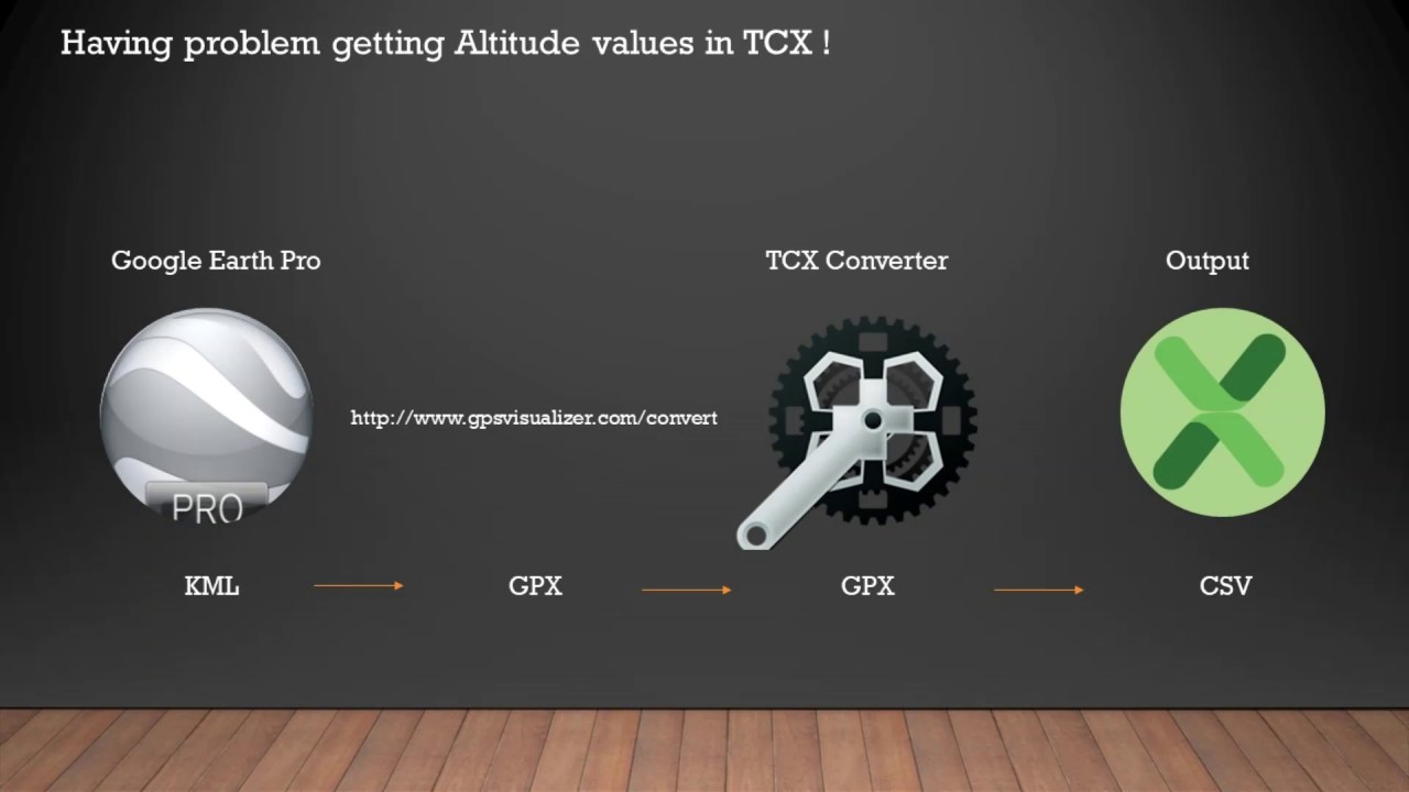
In this google earth pro tutorial, I will even show you how the process of extracting elevation data from google earth pro without even using TCX software!

We will extract google earth elevation without even using TCX Converter!!

UPDATED VERSION:    • How to Extract UTM Coordinates (Eastings a...  

==========
TIMESTAMP
==========

00:00 Introduction
00:31 Digitization on Google Earth
02:14 Save digitized data as KML file.
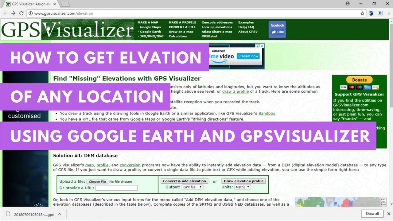
02:55 Extract elevation data with GPS Visualizer
06:48 Open and clean final data with MS Excel

How to Extract UTM Coordinates (Eastings and Northings) and Elevation data from Google Earth PRO:    • How to Extract UTM Coordinates (Eastings a...  

How to convert Latitude Longitude Coordinates to UTM :    • QGIS Tutorial - How to convert Latitude Lo...  

How to convert UTM to Latitude Longitude Coordinates :    • How to convert UTM to Latitude Longitude C...  

Extract Elevation Data FROM GOOGLE EARTH PRO | Google earth elevation data WITHOUT TCX Converter!

Поделиться в:

Доступные форматы для скачивания:

Скачать видео mp4

  • Информация по загрузке:

Скачать аудио mp3

Похожие видео

Как извлечь координаты UTM (восточное и северное положение) и данные о высоте из Google Earth PRO

Как извлечь координаты UTM (восточное и северное положение) и данные о высоте из Google Earth PRO

Convert Google Earth Contours to AutoCAD Using TCX Converter, QuickGrid & Surfer (DEM Method)

Convert Google Earth Contours to AutoCAD Using TCX Converter, QuickGrid & Surfer (DEM Method)

Extracting DEM from Google Earth & QGIS

Extracting DEM from Google Earth & QGIS

Extracting Elevation Data from Google Earth

Extracting Elevation Data from Google Earth

TCX Converter - Altitude Problem

TCX Converter - Altitude Problem

How to Import Excel/Survey Coordinates Into EPANET Software | EPANET Tutorial [Simplest Way]

How to Import Excel/Survey Coordinates Into EPANET Software | EPANET Tutorial [Simplest Way]

How to create DEM from Google Earth Pro | Extract Contour lines from Google Earth

How to create DEM from Google Earth Pro | Extract Contour lines from Google Earth

How to get elevation of any location using Google Earth

How to get elevation of any location using Google Earth

Создание контуров в QGIS с помощью Google Earth Pro

Создание контуров в QGIS с помощью Google Earth Pro

Водопроводная сеть на основе программного обеспечения Epanet; Часть 2

Водопроводная сеть на основе программного обеспечения Epanet; Часть 2

Altitude Values error in TCX

Altitude Values error in TCX

Extract Site Contours from Google Earth Directly into AutoCAD Using Global Mapper

Extract Site Contours from Google Earth Directly into AutoCAD Using Global Mapper

Earth’s 7 Lowest Points by Continent (“Seven Lows”) + Lowest under water & ice + Lowest by countries

Earth’s 7 Lowest Points by Continent (“Seven Lows”) + Lowest under water & ice + Lowest by countries

Как подготовить список объемов работ после проектирования системы водоснабжения в EPANET

Как подготовить список объемов работ после проектирования системы водоснабжения в EPANET

Как извлечь координаты из Google Earth

Как извлечь координаты из Google Earth

Create Contour from Google Earth to Civil 3D

Create Contour from Google Earth to Civil 3D

Extract coordinates from Google Earth Pro to Excel

Extract coordinates from Google Earth Pro to Excel

Учебное пособие по QGIS — Как преобразовать координаты широты и долготы в UTM | Простой способ — ...

Учебное пособие по QGIS — Как преобразовать координаты широты и долготы в UTM | Простой способ — ...

Download any images/DEM with Google Earth Engine (GEE)

Download any images/DEM with Google Earth Engine (GEE)

EPANET Tutorial | How to Import Excel/AutoCAD Data Into EPANET Software [Complete Guide]

EPANET Tutorial | How to Import Excel/AutoCAD Data Into EPANET Software [Complete Guide]

© 2025 dtub. Все права защищены.


  • Контакты
  • О нас
  • Политика конфиденциальности


Контакты для правообладателей: infodtube@gmail.com