Salauddin Rubel
Hi there! My name is Md. Salauddin, but you can call me Rubel. I graduated from Jagannath University with a degree in Geography and Environment, and I have a passion for GIS and Remote Sensing. In 2013, I created this channel to help my university friends prepare for their practical exams. However, I soon realized that practical experience is the best way to learn GIS and Remote Sensing. Training in these fields can be expensive and rare, so I decided to continue uploading video tutorials to help students, professionals, and researchers develop their skills in GIS and Remote Sensing.

How to Convert Shapefile Projection in ArcMap

Converting ArcGIS Shapefile To GeoJSON: Quick And Easy!

Cyclone Yass Satellite Observation | Latest Update of Cyclone Yass | 25 May 2021

Cyclone "Tauktae" Live Update | Landfall Observation | May 17 Evening

Cyclone "Tauktae" Live Satellite Observation | Latest Update | 17 May 2021 Morning

Cyclone "Taukte" Live Satellite Observation | Latest Update | 16 May 2021 Morning

Cyclone "Taukte" | Live Observation from Satellite | Latest Update of Cyclone "Taukte" | 15-05-2021

Cyclone "Taukte" Live Observation from Satellite | Cyclone in Arabian Sea | 15 May 2021 Morning

Latest Update of Cyclone NISARGA from Satellite for Last 12 Hours || Dated 3 June 2020, 10 PM IST

Latest Update of Cyclone NISARGA from Satellite for Last 12 Hours || Dated 3 June 2020, 6PM IST

Latest Update of Cyclone NISARGA from Satellite for Last 6 Hours || Dated 3 June 2020, 3 PM IST

Latest Update of Cyclone NISARGA from Satellite for Last 12 Hours || Dated 3 June 2020, 10AM IST

Cyclone NISARGA Latest Update from Satellite for Last 12 Hours || Dated 2 June 2020, 9 PM IST

Cyclone "AMPHAN" Observed from Satellite for last 12 hours || Dated 22 May 2020 at 0600 UTC

Real Time Satellite Observation of Tropical Cyclone TWENTYSEVEN || 22 May 2020 at 00 UTC

Cyclone "AMPHAN" Observed from Satellite for last 12 hours || Dated 21 May 2020 at 2300 UTC

Cyclone "AMPHAN" Observed from Satellite for last 12 hours || Dated 21 May 2020 at 06 UTC | 12PM BST

How to Extract Raster Multi Values to Points in ArcGIS

How to Extract Raster Values to Points in ArcGIS using Extract by Multi values Tool

How to Extract Raster Values to Points in ArcGIS

How to generate Zonal Statistics as Table in ArcGIS

How to convert a raster dataset to a point feature/shapefile in ArcGIS

Kriging Interpolation Technique using ArcGIS || A Surface Interpolation Technique in GIS

Measure Distance from Specific Point to other Features in ArcGIS

How to Fix Missing Spatial Reference in ArcGIS

How to create origin and destination map (XY to Line) in ArcGIS

How to install IBM SPSS version 23 with license
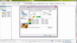
How to use quantities symbology in ArcMap

How To Install ArcGIS 10.4 With A License

How to georeference jpeg image map in arcmap part 1