Популярное

Музыка Кино и Анимация Автомобили Животные Спорт Путешествия Игры Юмор

Интересные видео

2025 Сериалы Трейлеры Новости Как сделать Видеоуроки Diy своими руками

Топ запросов

смотреть а4 schoolboy runaway турецкий сериал смотреть мультфильмы эдисон
dTub
Скачать

Strayos Academy: How to Set Ground Control Points for Greater Accuracy in Drone Mapping

Автор: Strayos

Загружено: 2021-01-05

Просмотров: 2199

Описание:

Ground Control Points (GCPs) give your model high precision accuracy🔎Learn the BEST techniques to placing GCPs for bench mapping in this how to video.

It's so simple to add GCP points to your mapping, watch now! ❌ 🚁🗺

LEARN MORE
👀 Watch another video on GCPs:    • Strayos Academy: GCP AI Tutorial  
📄 Read the how-to article: https://help.strayos.com/hc/en-us/art...
💻 Check out the Strayos Blog: https://blog.strayos.com/
📘 Download our Free E-Book: AI Guide for Drilling and Blasting: https://www.strayos.com/ai-guide-for-...

FOLLOW US
💌 Sign up for our Emails: https://www.strayos.com/contact.html
🌎 Visit the Website: https://www.strayos.com/
🙂 LinkedIn:   / strayos  
👷‍♂️ Facebook:   / strayos  
🦅 Twitter:   / strayosai  

GET IN TOUCH
Have questions?
Wanna see Strayos in action?
Contact us: https://www.strayos.com/contact.html

#StrayosAcademy #StrayosHowTo #StrayosAI #JonLewis #drones #UAV #mapping #photogrammetry #mining #quarry

TRANSCRIPT
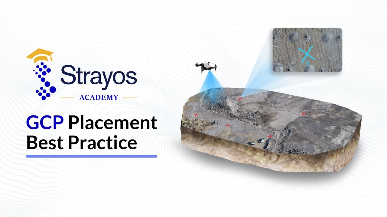
Hi, Welcome to the Strayos Academy. My name is Jon Lewis and I'm going to be talking about the best practices for placing ground control points before capturing the images that will be used to create the 3D model.

The first thing to consider is what is a good GCP marker?

1. The GCP marker should be clearly visible as a target. Try to ensure that its atleast 4x4 feet in dimension. Use high-contrast colors so that marker color doesn't blend with ground color. Giant X's are the easiest to place as well as the easiest for the AI to detect.
2. Each GCP marker should have sequence number.
3. Survey the center point using high precision GPS equipment for desired accuracy.

We suggest 5 GCP's, 3 on top of the bench and 2 on the bottom, that can be found in a minimum of 3 images. This means that you should consider your GCP placement relative to the image capture locations, if you put the GCP's on the very edge of the flight path the GCP's may not be visible in 3 images. This is important because the model is a collection of images and metadata and the only way to relate a GPS location to the model is by the GCP's to be shown in the actual base images. If you would like to see how the GCP's are uploaded and processed within the Strayos platform, please defer to the "GCP AI Tutorial"

I hope this video has been helpful, if you want to find more information or videos like this please navigate to the Strayos website which is [Strayos.com](http://strayos.com) , the link is in the description. Thank you so much for listening and I’ll see you in the next video!

Strayos Academy: How to Set Ground Control Points for Greater Accuracy in Drone Mapping

Поделиться в:

Доступные форматы для скачивания:

Скачать видео mp4

  • Информация по загрузке:

Скачать аудио mp3

Похожие видео

Strayos Academy: Rock Mass AI

Strayos Academy: Rock Mass AI

Картографирование с помощью дронов: подробное руководство для начинающих (2025)

Картографирование с помощью дронов: подробное руководство для начинающих (2025)

The Purpose of Ground Control Points, Volume of Stockpile With 10 GCPs Vs 0 GCPs | Aerial Surveying

The Purpose of Ground Control Points, Volume of Stockpile With 10 GCPs Vs 0 GCPs | Aerial Surveying

How to use GCPs for Drone Mapping?

How to use GCPs for Drone Mapping?

102 - Скрытый самодельный бросок на землю для работы под скамьей

102 - Скрытый самодельный бросок на землю для работы под скамьей

Что такое точность геодезической съемки? | Картографирование с помощью дронов и глубокое погружен...

Что такое точность геодезической съемки? | Картографирование с помощью дронов и глубокое погружен...

droneHOW - Episode 08 - Using ground control points in drone survey (Bentley ContextCapture)

droneHOW - Episode 08 - Using ground control points in drone survey (Bentley ContextCapture)

LiDAR

LiDAR

Aerial Survey How to Establish Site GCPs

Aerial Survey How to Establish Site GCPs

Pix4D Mapper Complete Tutorial: Drone Image Processing with Ground Control Points.

Pix4D Mapper Complete Tutorial: Drone Image Processing with Ground Control Points.

Как стать профессионалом в области картографирования с помощью дронов | Подробное погружение

Как стать профессионалом в области картографирования с помощью дронов | Подробное погружение

Я протестировал WebODM и нашел САМЫЙ БЫСТРЫЙ способ обработки фотографий!

Я протестировал WebODM и нашел САМЫЙ БЫСТРЫЙ способ обработки фотографий!

Strayos Academy: Strayos How to Use the Tools in the Toolbar

Strayos Academy: Strayos How to Use the Tools in the Toolbar

Ground Control Points | The Secret to Perfect Drone Maps!

Ground Control Points | The Secret to Perfect Drone Maps!

Что такое LiDAR-съемка с помощью дронов? Точность и результаты

Что такое LiDAR-съемка с помощью дронов? Точность и результаты

Agisoft Metashape - Complete Tutorial (Cloud, Mesh, DSM, DTM, Classify, Orthoimage - No GCPs)

Agisoft Metashape - Complete Tutorial (Cloud, Mesh, DSM, DTM, Classify, Orthoimage - No GCPs)

State of AI in the Mining Industry: 2025 Recap — What’s Real, What’s Not, and What’s Next

State of AI in the Mining Industry: 2025 Recap — What’s Real, What’s Not, and What’s Next

Эфир - Самое ЛЕТУЧЕЕ Вещество на Земле!

Эфир - Самое ЛЕТУЧЕЕ Вещество на Земле!

Where Did Your Ore Go? Cut dilution. Protect ore. Plan selective digging with ORBYM.

Where Did Your Ore Go? Cut dilution. Protect ore. Plan selective digging with ORBYM.

Data Capture Workflow: Understanding Ground Control for Drone Surveys

Data Capture Workflow: Understanding Ground Control for Drone Surveys

© 2025 dtub. Все права защищены.


  • Контакты
  • О нас
  • Политика конфиденциальности


Контакты для правообладателей: infodtube@gmail.com