Популярное

Музыка Кино и Анимация Автомобили Животные Спорт Путешествия Игры Юмор

Интересные видео

2025 Сериалы Трейлеры Новости Как сделать Видеоуроки Diy своими руками

Топ запросов

смотреть а4 schoolboy runaway турецкий сериал смотреть мультфильмы эдисон
dTub
Скачать

DJI Zenmuse L2: Using LiDAR Technology for Land Surveying Projects

Автор: DJI Enterprise

Загружено: 2024-08-12

Просмотров: 16188

Описание:

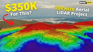
Discover how the DJI Zenmuse L2 is used by Adams Surveying, a Dallas-based surveying firm, to scan and create a topographic map of a creek along a construction project in Weston, Texas. Adams Surveying uses the Zenmuse L2 for various commercial land surveying services, including boundary surveys, design topographic surveys, construction layouts, and final as-built surveys.

Witness the precision of the advanced LiDAR technology within the Zenmuse L2, allowing them to create detailed 3D models of the ground beneath, even through dense tree canopies.

Whether you're interested in land surveying or topographic surveys, or simply curious about the process behind building in challenging terrains, this video provides a comprehensive overview of Zenmuse L2's capabilities and the technology supporting it.

DJI Zenmuse L2: Using LiDAR Technology for Land Surveying Projects

Поделиться в:

Доступные форматы для скачивания:

Скачать видео mp4

  • Информация по загрузке:

Скачать аудио mp3

Похожие видео

How Accurate is Drone LiDAR using DJI Zenmuse L2

How Accurate is Drone LiDAR using DJI Zenmuse L2

Levantamento Topográfico com LiDAR DJI L2 e Drone Matrice 350

Levantamento Topográfico com LiDAR DJI L2 e Drone Matrice 350

Я купил мини-экскаватор из Китая и ЭТО пришло!

Я купил мини-экскаватор из Китая и ЭТО пришло!

Почему гибнут дачники? И как спастись от смертельной утечки?

Почему гибнут дачники? И как спастись от смертельной утечки?

DJI Matrice 350 RTK + Zenmuse L2 LiDAR - unboxing and first takeoff

DJI Matrice 350 RTK + Zenmuse L2 LiDAR - unboxing and first takeoff

VAP using the new L2 LiDAR for topographic survey. LiDAR drone for hire

VAP using the new L2 LiDAR for topographic survey. LiDAR drone for hire

The RIGHT way to Calculate Volumes with Agisoft Metashape

The RIGHT way to Calculate Volumes with Agisoft Metashape

Сравнение точности LiDAR и камеры iPhone 16 Pro и геодезического тахеометра

Сравнение точности LiDAR и камеры iPhone 16 Pro и геодезического тахеометра

DJI Zenmuse L3: Monitoring Cliff Instability and Detecting Cracks Hidden by Vegetation

DJI Zenmuse L3: Monitoring Cliff Instability and Detecting Cracks Hidden by Vegetation

Photogrammetry VS LiDAR - Which Is BETTER?

Photogrammetry VS LiDAR - Which Is BETTER?

Стоит ли покупать DJI Zenmuse L2 LiDAR? (L2 против R3 Pro V2)

Стоит ли покупать DJI Zenmuse L2 LiDAR? (L2 против R3 Pro V2)

Deepdive: Understanding Drone LiDAR Technology & the DJI Zenmuse L1

Deepdive: Understanding Drone LiDAR Technology & the DJI Zenmuse L1

Серия глубоких погружений DJI L2 | Эпизод 1

Серия глубоких погружений DJI L2 | Эпизод 1

M400 vs M350: What’s New for LiDAR Surveying?

M400 vs M350: What’s New for LiDAR Surveying?

Картографирование с помощью дронов: подробное руководство для начинающих (2025)

Картографирование с помощью дронов: подробное руководство для начинающих (2025)

Не покупайте DJI Zenmuse L1, пока не увидите это! ROCK против RIEGL против DJI

Не покупайте DJI Zenmuse L1, пока не увидите это! ROCK против RIEGL против DJI

Navigating Tough Terrain: How DJI Zenmuse L2 Transforms Coastal Road Surveys

Navigating Tough Terrain: How DJI Zenmuse L2 Transforms Coastal Road Surveys

3D Model Start to Finish using DJI P1 flying RTK, Emlid RX on Emlid Caster Service, and DJI Terra

3D Model Start to Finish using DJI P1 flying RTK, Emlid RX on Emlid Caster Service, and DJI Terra

Как на самом деле выглядит проект LiDAR стоимостью 350 тысяч долларов?

Как на самом деле выглядит проект LiDAR стоимостью 350 тысяч долларов?

Картографирование с помощью дронов для строительства: полное руководство

Картографирование с помощью дронов для строительства: полное руководство

© 2025 dtub. Все права защищены.


  • Контакты
  • О нас
  • Политика конфиденциальности


Контакты для правообладателей: [email protected]