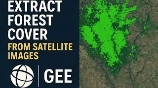
How To Make Forest Cover Change mapping using Google Earth Engine
Автор: TECH HIVE
Загружено: 2024-08-24
Просмотров: 571
Landcover Change Detection using Landsat 8 (Australian Forest Fires 2019-2020)
Land use and Land cover change detection & Calculate the transition zone using Google Earth Engine
Perform Forest Loss & Gain analysis using Earth Engine - 48
Create special designs for special moments with Canva.
How to make LANDUSE AND LAND COVER CHANGE mapping using Google Earth Engine | LULC change detection
Introduction | Filtering data | Training Point | Classifier | Classification Results | After Classification | Urban Area | Code | Result | Solution | Classification process | Reclassify | Overall change | After 2021 | Class 2021
Change Detection in Earth Engine
NDVI Change Detection Analysis using Landsat 8 | Google Earth Engine
Change Detection of Vegetation Cover by NDVI Technique using Google Earth Engine
How to Load Sentinel 2 imagery in Google Earth Engine | Beginners Guide
Google Earth Engine -Time Series NDVI Extraction from MODIS and Sentinel-2 Data
Introduction | Time Series NDVI Extraction from MODIS data | Time Series NDVI Extraction from Sentinel-2 (MSI) data
Live Google Earth Engine For Making Land Use and Land Cover Mapping using Machine learning Method
Import the Image Collection | Filter the Image Properties | Filter Metadata | Create the Buffer | Create the Training Data Set | Sample Regions | Random Column | Create the Classifier Model or Machine Learning Model | Input Properties | Create the Confusion Matrix Table
Supervised Image Classification of Sentinel 2A Imagery in Google Earth Engine | Part - 2
crop Classification & Mapping for Agricultural Land from Satellite Images using Google Earth Engine
Google Earth Engine Tutorial-65: Crop Type Detection using Multi-Temporal SAR Images
Google Earth Engine with Amirhossein Ahrari
Supervised classification using Sentinel 2A Imagery | Google Earth Engine
Quantifying Forest Change using Google Earth Engine
How to make Land use and Land cover Change detection using Google Earth Engine for big region || GEE
Vector area | Single class | Urban area | Reduce region | Change detection | Change detection for all classes
Supervised Classification with Sentinel 2 Satellite Images | Earth Engine | Machine Learning
Introduction | Importing Data | Loading Sentinel Image | Importing Satellite Image | Cloud Contamination | Creating Training Data | Capture Training Data | Aggregate Training Data | Extract Training Data | Separate Training Validation Data | Display Data | Accuracy Assessment | Export Data
Landslide Susceptibility Assessment using Frequency Ratio Approach/ PART-2
Land Use Land Cover Change (LULCC) between 2001 and 2019 in Google Earth Engine (Study Area: Dharan)
Classification and Regression Trees (CART): Machine learning technique in Google Earth Engine. In this tutorial learn how to: 1.
Vegetation Change Detection using NDVI in Google Earth Engine || NDVI change detection.
Google Earth Engine Tutorial: Charting Forest Cover Loss By Year - Hansen-GFC 2000-2019
NDVI change detection and Calculate the total Area of Dense vegetation using Google Earth Engine
Intro | NDVI change detection | Calculate NDVI area | Reduce NDVI area
Satellite Image classification Random Forest (RF) Machine Leaning (ML) in Google Earth Engine (GEE)
Link :https://drive.google.com/file/d/1z_rt...

Доступные форматы для скачивания:
Скачать видео mp4
-
Информация по загрузке: