Популярное

Музыка Кино и Анимация Автомобили Животные Спорт Путешествия Игры Юмор

Интересные видео

2025 Сериалы Трейлеры Новости Как сделать Видеоуроки Diy своими руками

Топ запросов

смотреть а4 schoolboy runaway турецкий сериал смотреть мультфильмы эдисон
dTub
Скачать

Extract Individual Wavelength Layers from Agisoft and Reassemble in 3 Band RGB or NGB Imagery

Автор: LSUPrecisionAg

Загружено: 2021-05-24

Просмотров: 1427

Описание:

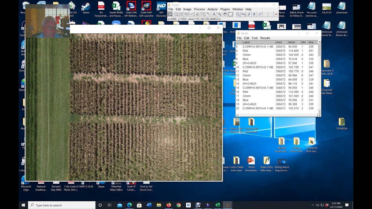
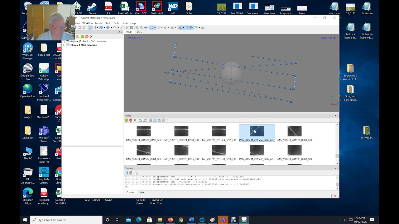
This video will help you extract individual wavelength layers from multi-spectral Agisoft Metashape Orthos and reassemble into more standard RGB type files (3 wavelength, 8-bit files) for analysis or indices calculations with other programs.

Extract Individual Wavelength Layers from Agisoft and Reassemble in 3 Band RGB or NGB Imagery

Поделиться в:

Доступные форматы для скачивания:

Скачать видео mp4

  • Информация по загрузке:

Скачать аудио mp3

Похожие видео

Getting Parrot Sequoia Images into Agisfot for Composite Image Generation

Getting Parrot Sequoia Images into Agisfot for Composite Image Generation

Using QGIS to Segment Orthomosaics and Extract Drone Data

Using QGIS to Segment Orthomosaics and Extract Drone Data

Positive Mood Jazz ☕ Cozy Winter Coffee Jazz Music and Sweet Bossa Nova Piano for Energy the day

Positive Mood Jazz ☕ Cozy Winter Coffee Jazz Music and Sweet Bossa Nova Piano for Energy the day

REM 475 Lab: Multispectral Image Processing, Part 1

REM 475 Lab: Multispectral Image Processing, Part 1

Combining Drone Lidar with Photogrammetry in Metashape

Combining Drone Lidar with Photogrammetry in Metashape

DroneCamp 2020: Drone Imagery Processing with Agisoft Metashape

DroneCamp 2020: Drone Imagery Processing with Agisoft Metashape

¿Cómo configurar el flujo de trabajo para procesar imágenes con Agisoft Metashape?

¿Cómo configurar el flujo de trabajo para procesar imágenes con Agisoft Metashape?

Multispectral Imagery Analysis

Multispectral Imagery Analysis

How to process RGB and multispectral drone imagery in Pix4D (Drones in agriculture series, 2/10)

How to process RGB and multispectral drone imagery in Pix4D (Drones in agriculture series, 2/10)

Как сжимаются изображения? [46 МБ ↘↘ 4,07 МБ] JPEG в деталях

Как сжимаются изображения? [46 МБ ↘↘ 4,07 МБ] JPEG в деталях

Учебное пособие по Agisoft Metashape (базовый рабочий процесс)

Учебное пособие по Agisoft Metashape (базовый рабочий процесс)

Using ImageJ and Excel to Turn Drone Imagery and Plots into Numerical Data

Using ImageJ and Excel to Turn Drone Imagery and Plots into Numerical Data

ЗАЧЕМ ТРАМПУ ГРЕНЛАНДИЯ? / Уроки истории @MINAEVLIVE

ЗАЧЕМ ТРАМПУ ГРЕНЛАНДИЯ? / Уроки истории @MINAEVLIVE

Изучите Microsoft Active Directory (ADDS) за 30 минут

Изучите Microsoft Active Directory (ADDS) за 30 минут

Webinar: Uygulamalar İle Multispektral Görüntüleme

Webinar: Uygulamalar İle Multispektral Görüntüleme

Agricultura de Precisión: Procesamiento de Datos Multiespectrales en Agisoft Metashape

Agricultura de Precisión: Procesamiento de Datos Multiespectrales en Agisoft Metashape

Изучите редактирование фотографий в GIMP 3.0 для начинающих за 25 минут

Изучите редактирование фотографий в GIMP 3.0 для начинающих за 25 минут

Using Agisoft Metashape Pro and Drone Imagery to Make a Shape File and Prescription Map

Using Agisoft Metashape Pro and Drone Imagery to Make a Shape File and Prescription Map

Выучите R за 39 минут

Выучите R за 39 минут

«Нас ждут тектонические сдвиги»: зачем Трамп создал кризис вокруг Гренландии

«Нас ждут тектонические сдвиги»: зачем Трамп создал кризис вокруг Гренландии

© 2025 dtub. Все права защищены.


  • Контакты
  • О нас
  • Политика конфиденциальности


Контакты для правообладателей: infodtube@gmail.com