Building Google Earth Engine Pipelines for Sentinel-2 NDVI | Advanced Geospatial AI
Автор: Dr. Azad Rasul
Загружено: 2025-09-16
Просмотров: 83
Welcome to a new Lecture of Advanced Geospatial AI: Deep Learning for Satellite Imagery Analysis! In this tutorial, we dive into building automated data pipelines with Google Earth Engine (GEE) to process Sentinel-2 imagery for deep learning. Building on Lecture 8’s tiling of a large image into 16 patches, we create a streamlined pipeline to retrieve a Sentinel-2 image, compute NDVI (Normalized Difference Vegetation Index), and export it as a NumPy array, ready for CNN preprocessing. Follow along in Colab to master scalable geospatial workflows! What You’ll Learn: How to automate Sentinel-2 image retrieval using GEE.
Computing NDVI for vegetation analysis, extending Lecture 6’s indices.
Exporting processed data as a NumPy array for deep learning.
Setting the stage for tiling and CNN training, as in Lecture 8.
Demo Highlights:
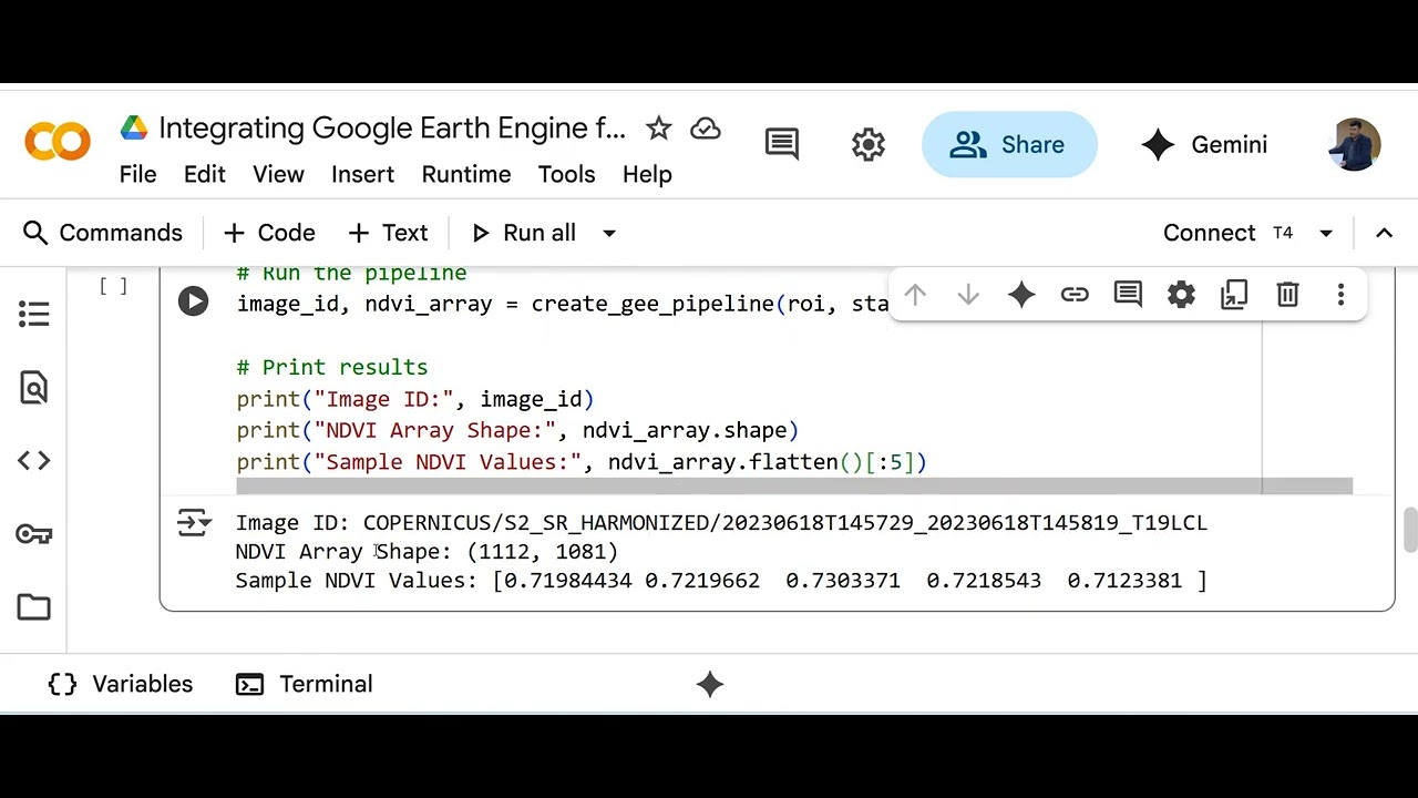
We build a GEE pipeline for a 1x1 km region in Brazil (June 2023), computing NDVI with NIR and red bands. Check out the output: Image ID: COPERNICUS/S2_SR_HARMONIZED/20230618T145151_20230618T145149_T22JCR
NDVI Array Shape: (1112, 1081)
Sample NDVI Values: [0.71984434, 0.7219662, 0.7303371, 0.7218543, 0.7123381]
These values (~0.72) indicate healthy vegetation, perfect for crop monitoring tasks. Resources: Jupyter Notebook: Run the pipeline code (linked in the pinned comment or course platform).
Geospatial AI Guide PDF: Excerpt on GEE pipelines and NDVI computation (available via course).
Assignment: Modify the pipeline for a new region, compute NDVI, and optionally tile it like Lecture 8. Share your results!
Quiz: Test your knowledge with 5 questions
Next Steps: Run the notebook in Colab to compute NDVI for your own region.
Complete the assignment: Process a new Sentinel-2 image and share your NDVI values in the comments!
Join us in Lecture 10 for transfer learning with pre-trained CNNs, using NDVI and tiled data.
Let’s Connect:
What NDVI values did you get for your region? How do they reflect land cover? Drop your results or questions below! Like, subscribe, and hit the bell for more geospatial AI tutorials.
#GeospatialAI #GoogleEarthEngine #Sentinel2 #NDVI #DeepLearning #SatelliteImagery #DataScience #RemoteSensing
Доступные форматы для скачивания:
Скачать видео mp4
-
Информация по загрузке:


![Как происходит модернизация остаточных соединений [mHC]](https://image.4k-video.ru/id-video/jYn_1PpRzxI)


