Популярное

Музыка Кино и Анимация Автомобили Животные Спорт Путешествия Игры Юмор

Интересные видео

2025 Сериалы Трейлеры Новости Как сделать Видеоуроки Diy своими руками

Топ запросов

смотреть а4 schoolboy runaway турецкий сериал смотреть мультфильмы эдисон
dTub
Скачать

Routing pollution over the flow direction with PCRaster in QGIS

Автор: Hans van der Kwast

Загружено: 2021-05-19

Просмотров: 1735

Описание:

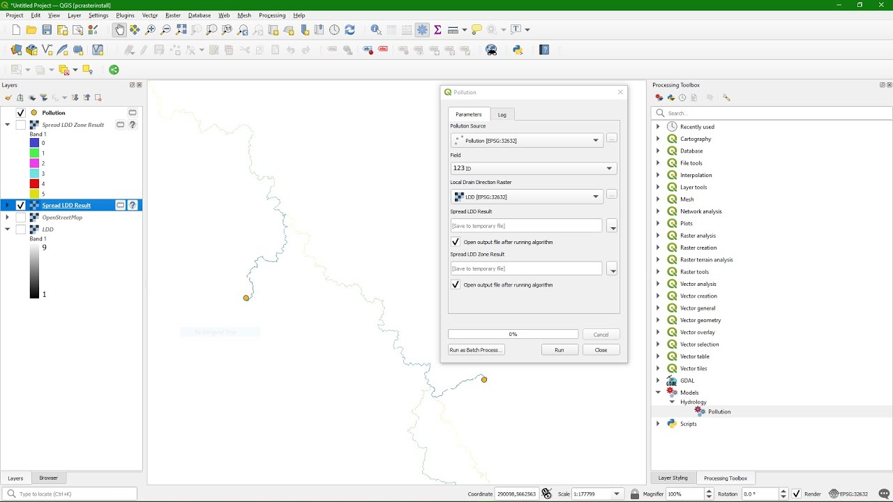
The first part of the video shows how to use PCRaster tools in QGIS to route pollution over the local drain direction raster. In the second part we'll build a tool for this in the Graphical Modeler.

PCRaster tools used: lddcreate, spatial, cover, spreadldd, spreadlddzone, path

The pollution model can be downloaded here: https://github.com/jvdkwast/pcrastert...

Link to repository: https://github.com/jvdkwast/qgisrepos...

Linkt to PCRaster: http://www.pcraster.eu

0:00 Pollution routing
11:13 Implementation in the Graphical Modeler

#PCRaster #QGIS

Routing pollution over the flow direction with PCRaster in QGIS

Поделиться в:

Доступные форматы для скачивания:

Скачать видео mp4

  • Информация по загрузке:

Скачать аудио mp3

Похожие видео

Как выполнить геопривязку в QGIS (2024)

Как выполнить геопривязку в QGIS (2024)

Derive Urban Footprint with QGIS

Derive Urban Footprint with QGIS

One-click Digitizing in QGIS: Use Segmentation and GeoAI to SAVE TIME with the Geo-SAM Plugin!

One-click Digitizing in QGIS: Use Segmentation and GeoAI to SAVE TIME with the Geo-SAM Plugin!

Study area

Study area

Introduction to the Geospatial Abstraction Library (GDAL) with the new CLI

Introduction to the Geospatial Abstraction Library (GDAL) with the new CLI

Обзор плагина QGIS GeoAI

Обзор плагина QGIS GeoAI

How to create Pakistan Population Density Map render in QGIS and 3D raytracing Tutorial

How to create Pakistan Population Density Map render in QGIS and 3D raytracing Tutorial

Удивительное изобретение 65-летнего плотника поразило инженеров! Самодельные инструменты для деревоо

Удивительное изобретение 65-летнего плотника поразило инженеров! Самодельные инструменты для деревоо

⚡️СРОЧНО! Первые ПОДРОБНОСТИ ПЕРЕГОВОРОВ по войне: БУДЕТ ПЕРЕМИРИЕ? Москва ПРИНЯЛА РЕШЕНИЕ ПО

⚡️СРОЧНО! Первые ПОДРОБНОСТИ ПЕРЕГОВОРОВ по войне: БУДЕТ ПЕРЕМИРИЕ? Москва ПРИНЯЛА РЕШЕНИЕ ПО "СВО"

QGIS essentials for water modelling

QGIS essentials for water modelling

Никакого газа, никаких дров 😱!! Эта простая самодельная печь отапливает дом БЕСПЛАТНО всю зиму

Никакого газа, никаких дров 😱!! Эта простая самодельная печь отапливает дом БЕСПЛАТНО всю зиму

QGIS - Landscape Ecology Statistics (LecoS) Part I

QGIS - Landscape Ecology Statistics (LecoS) Part I

Как делают самые прочные якорные цепи в мире | by @Satisfyingtech116

Как делают самые прочные якорные цепи в мире | by @Satisfyingtech116

Add Data Plotly Graphs to the QGIS Print Layout

Add Data Plotly Graphs to the QGIS Print Layout

ЖДАНОВ: Вот кого нашли ПОД ЗАВАЛАМИ НА ПОДОРВАННОЙ БАЗЕ РФ! Первые некрологи, разведка все слила

ЖДАНОВ: Вот кого нашли ПОД ЗАВАЛАМИ НА ПОДОРВАННОЙ БАЗЕ РФ! Первые некрологи, разведка все слила

Установите инструменты PCRaster, SAGA и GRASS для QGIS с помощью установщика OSGeo4W.

Установите инструменты PCRaster, SAGA и GRASS для QGIS с помощью установщика OSGeo4W.

Introduction to the PCRaster Environmental Modelling Language

Introduction to the PCRaster Environmental Modelling Language

Что не так с “Орешником”? “Болванка”, которая встряхнула НАТО

Что не так с “Орешником”? “Болванка”, которая встряхнула НАТО

Calculate Subcatchment Properties in QGIS

Calculate Subcatchment Properties in QGIS

Visualising Wind from a GRIB Mesh Layer in QGIS and Create an Animated GIF

Visualising Wind from a GRIB Mesh Layer in QGIS and Create an Animated GIF

© 2025 dtub. Все права защищены.


  • Контакты
  • О нас
  • Политика конфиденциальности


Контакты для правообладателей: infodtube@gmail.com