🗺️ Tutorial 4.10 | ArcGIS Pro 3.6 | Add Raster & Visual Optimisation
Автор: Planificare UBB
Загружено: 2026-01-04
Просмотров: 22
📍 SERIA 4: Fotogrametrie UAV/UAS pentru Zone Mari | SERIES 4: UAV/UAS Photogrammetry for Large Areas | 4. SOROZAT: UAV/UAS Fotogrammetria Nagy Területekre
🎯 Tutorial 4.10 | Importul Ortofotoplanului: Calculul statisticilor şi Optimizarea vizuală (DRA) | Importing the Orthomosaic: Calculating Statistics and Visual Optimisation (DRA) | Az ortofotomozaik importálása: Statisztikai számítások és vizuális optimalizálás (DRA)
🇷🇴 Importul corect: Fundația analizei vizuale în ArcGIS Pro!
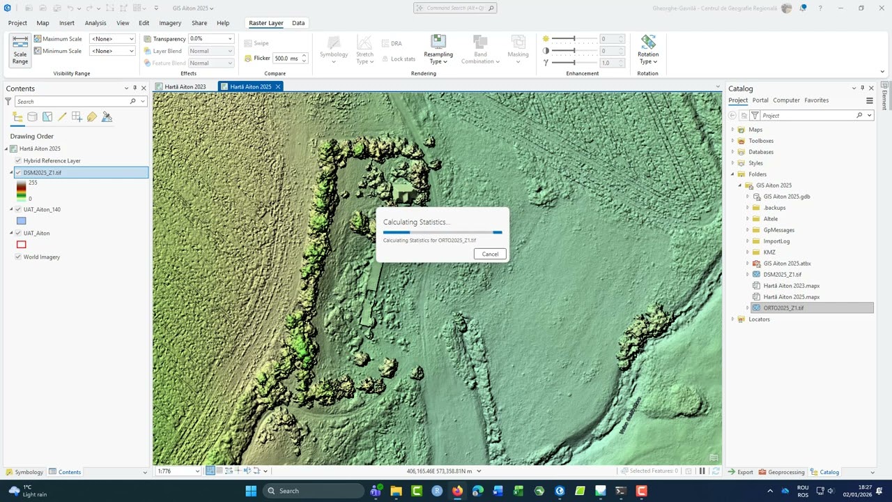
Aducerea ortofotoplanului (.tif) în ArcGIS Pro reprezintă momentul integrării datelor fotogrammetrice în mediul GIS. Un pas esențial, deși consumator de timp, este calcularea Statisticilor și a Piramidelor. Acestea permit software-ului să înțeleagă distribuția valorilor pixelilor și să asigure o navigare fluidă. Ulterior, utilizarea meniului Raster Layer ne permite ajustarea fină a randării pentru a evidenția detaliile morfologice sau starea vegetației.
Workflow & Decizii Tehnice:
1️⃣ Calculate Statistics: Am optat pentru calcularea statisticilor la import pentru a debloca funcțiile avansate de contrast și luminozitate. Deși durata procesului crește, acesta este obligatoriu pentru analize riguroase.
2️⃣ Dynamic Range Adjustment (DRA): Din meniul Enhancement, am activat funcția DRA. Aceasta ajustează automat contrastul pe baza pixelilor vizibili pe ecran, oferind o claritate superioară în zonele cu umbre sau reflexii puternice.
3️⃣ Rendering & Stretch: Ajustarea culorilor prin metode de Stretch (precum Percent Clip sau Standard Deviation) transformă imaginea brută într-un document cartografic uşor de interpretat pentru planificare.
🇬🇧 Proper Import: The Foundation of Visual Analysis in ArcGIS Pro!
Importing the orthomosaic (.tif) into ArcGIS Pro marks the integration of photogrammetric data into the GIS environment. A key step, although time-consuming, is calculating Statistics and Pyramids. These enable the software to understand the distribution of pixel values and ensure fluid navigation. Subsequently, the Raster Layer menu allows us to fine-tune the rendering to highlight morphological details or vegetation health.
Workflow & Technical Decisions:
1️⃣ Calculate Statistics: We opted to calculate statistics upon import to unlock advanced contrast and brightness functions. Although it increases processing time, it is mandatory for rigorous analysis.
2️⃣ Dynamic Range Adjustment (DRA): From the Enhancement menu, we enabled DRA. This automatically adjusts contrast based on the pixels currently visible on screen, providing superior clarity in areas with deep shadows or high reflections.
3️⃣ Rendering & Stretch: Colour adjustment through Stretch methods (such as Percent Clip or Standard Deviation) transforms the raw image into an easy-to-interpret cartographic document for planning purposes.
🇭🇺 Helyes importálás: A vizuális elemzés alapja az ArcGIS Pro-ban!
Az ortofotomozaik (.tif) ArcGIS Pro-ba való importálása a fotogrammetriai adatok térinformatikai környezetbe történő integrálását jelenti. Alapvető, bár időigényes lépés a Statisztikák és a Piramisok kiszámítása. Később a Raster Layer menü lehetővé teszi a megjelenítés finomhangolását a morfológiai részletek kiemelése érdekében.
Munkafolyamat és technikai döntések:
1️⃣ Statisztikák kiszámítása: Szükséges a fejlett kontraszt- és fényerőfunkciók feloldásához.
2️⃣ Dynamic Range Adjustment (DRA): Az Enhancement menüben aktiváltuk a DRA funkciót, amely automatikusan beállítja a kontrasztot a képernyőn látható pixelek alapján.
3️⃣ Megjelenítés és nyújtás: A színek beállítása a Stretch módszerekkel a nyers képet könnyen értelmezhető térképészeti dokumentummá alakítja.
📚 RESURSE SUPLIMENTARE:
🔗 Site Facultate Geografie UBB: geografie.ubbcluj.ro
🎬 Tutorial anterior (4.9 - Export Orthomosaic): • 🗺️ Tutorial 4.9 | Agisoft Metashape 2.2 | ...
#ArcGISPro #RasterLayer #DRA #Statistics #VisualOptimisation #UAV #GIS #Mapping #Orthomosaic #RemoteSensing #SpatialAnalysis #GeographyUBB #seria4
🎓 DESPRE NOI:
Planificare Teritorială (licență) și Planificare și Dezvoltare Regională (master), Facultatea de Geografie, Universitatea Babeș-Bolyai Cluj-Napoca.
Доступные форматы для скачивания:
Скачать видео mp4
-
Информация по загрузке:


