All Important RIVERS of BIHAR in ONE CLASS | SMART Revision with Animation | OnlyIAS
Автор: OnlyIAS Extended
Загружено: 2023-11-21
Просмотров: 107566
To Get More Information about Online/Offline Courses: https://counselling.pwonlyias.com/qp....
For Inquiries 📞 08071174446
In this video, we'll learn about all the rivers of Bihar, India which are part of himalayan river system.
.......................................................................................................................................................
Here’s a concise summary of Bihar’s Geography for UPSC preparation:
1. Location & Borders
Bihar is located in Eastern India.
It is landlocked and shares borders with Nepal to the north, and Indian states Uttar Pradesh (west), Jharkhand (south), and West Bengal (east).
2. Physiography
Northern Plains: Fertile alluvial plains formed by the Ganga River and its tributaries. It is part of the Gangetic Plain and is highly suitable for agriculture.
Southern Bihar: Consists of Chotanagpur Plateau fringes, with rugged terrain and hilly regions.
Ganga River: Divides Bihar into north and south. The river flows west to east and is joined by several major rivers.
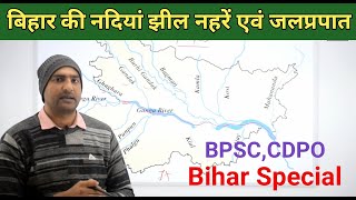
3. Rivers
Ganga River: The most prominent river, flowing through the heart of Bihar.
Tributaries of the Ganga: Ghaghara, Gandak, Kosi, Son, Punpun, and Bagmati. Rivers in northern Bihar often cause floods.
Kosi River: Known as the "Sorrow of Bihar" due to frequent and devastating floods.
4. Climate
Tropical monsoon climate.
Summers are hot and humid (March to June) with temperatures up to 45°C.
Monsoon season: From June to September, bringing heavy rainfall (annual average: 1200 mm).
Winters (December to February) are cool and mild with temperatures as low as 5°C.
5. Soil
Alluvial soils dominate, particularly in the plains, making Bihar one of the most agriculturally productive states.
Fertile soils support crops like rice, wheat, maize, sugarcane, and pulses.
Northern Bihar's soil is prone to waterlogging due to frequent floods.
6. Agriculture
Agriculture is the backbone of Bihar’s economy.
Key crops: Rice, wheat, maize, pulses, sugarcane, and oilseeds.
Kharif crops are dominant due to the monsoon rains.
Green Revolution benefits have been limited, but recent initiatives aim to modernize agriculture.
7. Forests
Forest cover is low, around 7% of the state's total area.
The forested regions are mainly located in the southern districts like Jamui and Kaimur.
Types of forests: Tropical deciduous forests with trees like sal, teak, and bamboo.
8. Natural Hazards
Floods: Northern Bihar is prone to frequent flooding, especially from the rivers Gandak, Kosi, and Bagmati.
Droughts: Southern and central Bihar occasionally face droughts during weak monsoon seasons.
9. Biodiversity
Notable wildlife sanctuaries include Valmiki National Park and Sanctuary in the West Champaran district, which is home to tigers, leopards, and deer.
Kaimur Wildlife Sanctuary is another important biodiversity hotspot.
10. Urban Centers
Major cities include Patna (the capital), Gaya, Bhagalpur, and Muzaffarpur.
Patna is the largest and one of the oldest continuously inhabited cities in the world.
This summary provides an overview of Bihar's geography, which is essential for understanding its agriculture, economy, and environmental challenges for UPSC preparation.

Доступные форматы для скачивания:
Скачать видео mp4
-
Информация по загрузке: