Welcome to Geospatial AI: Deep Learning for Satellite Imagery | Course Overview
Автор: Dr. Azad Rasul
Загружено: 2025-09-19
Просмотров: 70
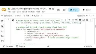
Ready to unlock the power of AI in geospatial analysis? Join us in this introductory lecture for Geospatial AI: Deep Learning for Satellite Imagery! In this video, we dive into what you’ll learn in this comprehensive 4+ hour course on Udemy (https://www.udemy.com/course/geospati.... Discover how to apply deep learning to satellite imagery for real-world applications like crop health analysis, weather emulation, and more. We’ll walk you through the course structure, from setting up your GPU environment and using Google Colab to building convolutional neural networks (CNNs) and preprocessing Sentinel-2 imagery. Perfect for data scientists, GIS professionals, or anyone curious about AI and remote sensing—no prior satellite imagery experience required! What you’ll learn:
Foundations of geospatial AI and Python
Cloud-based AI with Google Colab
Preprocessing satellite imagery with Google Earth Engine
Building CNNs for tasks like crop health classification
Advanced applications like plant counting and biomass prediction
Get ready to transform satellite data into actionable insights!
Enroll now and start your journey: https://www.udemy.com/course/geospati...
#geospatialai #DeepLearning #SatelliteImagery #ArtificialIntelligence #Python #GoogleColab
Доступные форматы для скачивания:
Скачать видео mp4
-
Информация по загрузке: